Saturday, May 5, 2012

Strong cap eliminates Nebraska tornado potential on 5/5/12


Saturday 5/5/12 over Nebraska was a good example of a "cap" bust where the surface warm sector was overlain by warm temperatures aloft at around 10,000 ft MSL (the "cap", see 700 mb 9 deg C isotherm on SPC graphics above through the day) that kept warm sector storms from forming.  This effectively eliminated any tornado potential for a day that had looked much more threatening on computer models a couple days before.  My wife Shawna and I saw this looking at morning and early afternoon data, and were concerned that daytime storms would be limited to the elevated environment north of the surface front .  So we elected not to storm chase today.


The chart above is a rough seasonal guideline I use regarding 700 mb temperatures that estimate the "cap" during maximum heating in the Central Plains.  Notice that 9 deg C (give or take a degree) is a very rough estimate of the "cap" in early May, and that was a good indicator today using the earlier SPC graphics.


The SW-NE stationary surface boundary over Nebraska (see map above) was "covered" by this cap through most of the day, which kept storms from initiating over central and northeast Nebraska in the warm sector.  It can also be seen on the SPC SBCAPE and EHI graphics above that the first cell to form in the evening was well north of this surface boundary in South Dakota and far away from a truly surface-based environment.  Storms did form in a line around and after dark behind the front (not shown) as the cap eroded from the west with the approach of an upper short wave of energy.  But the warm sector tornado threat was eliminated by the cap.

Yesterday, it came to my attention that someone was passing around Facebook a version of the SRH-CAPE chart I posted last year to suggest environment potential (low-level wind shear and instability) for significant tornadoes, using that to show how 5/5/12 would be a big tornado day in Nebraska.   Well... What actually happened on 5/5/12 is major reminder that tornado forecasting is about a lot more than just environment...  It involves assessing the surface pattern and warm sector orientation relative to where storms initiate (see my last post about April 27), as well the positioning and evolution of any "capped" areas that can keep storms from developing.  Severe weather forecasting is not simple stuff.

- Jon Davies 5/5/12

Monday, April 30, 2012

April 27 and April 21, 2012: Examples of boundaries hurting & helping tornado potential


Last Friday's (4/27) SPC outlook with a moderate risk and strong tornadoes expected in central and eastern KS did not really verify (there were only 2 or 3 very brief EF0 tornado reports with no damage). Looking back, this case was a good example of a narrow warm sector where, although ingredients (CAPE and wind shear) looked very supportive of supercell tornadoes, storms persistently formed too close to a surface stationary frontal boundary.  They moved across it and into a cooler surface environment where they rapidly became elevated supercells (not surface-based), with the only lifted parcels that could produce CAPE/instability coming from well above ground, which worked against tornadoes.

To illustrate this, the first graphic above shows surface-based (SB)CAPE and storm-relative helicity (SRH, low-level wind shear) from the SPC mesoanalysis at 7 pm CDT when a tornado-warned storm was moving into Topeka KS from the southwest.  Notice how far north of the surface warm sector (indicated by SBCAPE) this cell was located.  As seen from the Topeka Rapid Refresh sounding at the same time (2nd graphic above; no observed sounding was done due to ongoing severe weather), this environment was clearly elevated, with no CAPE from lifted parcels near the ground.  Even though SRH was quite large, it is difficult for tornadoes to develop in such an elevated setting north of a stationary surface boundary, and any tornadoes that could manage to develop here would be weak and very brief.   Because supercell storms could not spend much time in the surface-based warm sector before crossing the stationary boundary into much cooler surface air, the supercell tornado threat as originally anticipated could not materialize.


The Saturday before (4/21) in the northern plains saw another type of boundary generate a surprise round of weak (EF0-EF1, see storm report map and photo above) tornadoes in western Minnesota that were not expected.  These were non-supercell tornadoes that developed from enhanced stretching processes along a sharp north-south surface wind-shift boundary that provided vorticity for spin.  With very cold air aloft, a vertically compact area of CAPE (see the sounding above) developed from surface heating accompanied by very steep low-level lapse rates.  Both of these factors increased the potential for strong low-level stretching as storms formed along the surface boundary, which resulted in several tornadoes that did some damage to farmsteads.  Notice on the SPC graphics above that the overlapping of steep low-level lapse rates with low-level CAPE suggested very well the enhanced stretching environment along and just west of the boundary (see my paper with Jim Caruso here).  This was also indicated by the SPC Non-supercell Tornado parameter (also shown above), which incorporates these same ingredients.

So, 4/21 was an example of a different type of boundary that helped rather than hurt tornado potential.  Fortunately, difficult-to-forecast events like these usually produce generaly weak tornadoes and don't happen that often.  One certainly would not expect tornadoes in April with northwest flow aloft and surface dew points only in the 40's F (quite unusual!!!).  But a look back shows that some required ingredients for non-supercell tornadoes were there.

- Jon Davies  4/30/12

Sunday, April 22, 2012

Tornadoes after dark most dangerous during April 14 outbreak


Much has been written and many photos posted from last week's major outbreak of tornadoes on Saturday April 14, 2012.   The most damaging and deadly tornadoes turned out to be after dark, including the EF3 tornado that hit the southeast side of Wichita KS ($140 million damage), and the EF3 tornado that struck the Woodward OK area around midnight killing 6 people.

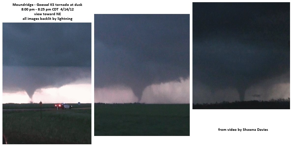
Above, grabs from video by my wife Shawna near and after dark in the Moundridge-Goessel and Marion areas of central KS show tornadoes visible only by lightning, including a large one near Marion Lake.  Associated maps and radar images above also show the tornado paths from that supercell, as well as the more prolific supercell that struck Wichita around 10:20 pm and produced other tornadoes before and after, also after dark.

Tornadoes after dark are particularly dangerous because they are difficult to see, and many people are asleep and not aware of what's approaching.  My paper with Andy Fischer about nighttime tornado environments (see here) shows that tornadoes after dark in the Plains occur when both CAPE and especially low-level shear are large after sunset.  Just as important, storms after dark need to remain relatively "surface-based" (lifted parcels of air near the ground that feed updrafts are able to move upward with little resistance).  This occurs when surface temperatures don't cool much and surface dew points remain steady or even increase, keeping convective inhibition (CIN) relatively small, rather than the more typical scenario where storms become "elevated" above a cool stable layer near the ground when surface temperatures cool significantly after sunset.


CAPE below 3 km  (CAPE closer to the ground) can also be an indicator of a more surface-based environment.  Notice that in the 2 graphics immediately above, along with large CAPE-shear combinations (suggested by both the Sig Tor parameter and the energy-helicity index), there were significant amounts of low-level CAPE indicated after dark on both the SPC mesoscale analysis in real-time, and on model forecasts in advance.  This suggested a continuation of the April 14 tornado event well after dark, which was the case, particularly with the Wichita KS and Woodward OK tornadoes.

Obviously, with this big an outbreak, it is very fortunate that more people weren't killed.  I can't emphasize enough the excellent forecasts and outlooks several days in advance, as well as pin-point warnings and media coverage during the event.

When I get time this coming week, I'll do a post about the setting that generated tornadoes in Minnesota yesterday (4/21/12) with early spring northwest flow aloft and 40's F dew points at the surface (very unusual!).

- Jon Davies  4/22/12

Wednesday, April 11, 2012

"Surviving the Storm: What Storm Chasers Want You to Know" DVD now available!


As I announced at ChaserCon 2012 in Denver, my wife Shawna Davies has spent much of the past year putting together a 30-minute severe weather safety/preparedness program working with several other storm chasers, including James Skivers, Stephen Locke, and Bill and Anna Stromberg. It's now available on DVD for $13.95 at:
************** www.survivingthestormmovie.com **************

With this project, Shawna wanted to use storm chaser knowledge and experience to do something good, apart from the usual storm chasing videos. Here's some excerpts from the Press Release:

With death and injury tolls from tornadoes in 2011 that were staggering, a group of professional storm chasers decided to use their considerable experience with violent weather to make an instructive and entertaining DVD to help people save their own lives when severe weather strikes. This DVD is titled “Surviving the Storm: What Storm Chasers Want You to Know”.

This 30 minute program provides life-saving tips and strategies for individuals and families to protect themselves against all types of severe weather... Safety segments show how to increase survival chances when violent weather strikes both indoors and out, including on the road. In addition, on-the-street interviews quiz people about severe weather knowledge with humor and wit, and a heart-pounding finale shows a mother and daughter acting to save their lives as a tornado strikes their home. Through use of exciting storm chaser footage and re-enactments of life threatening situations, this DVD offers an abundance of knowledge to survive deadly storms and severe weather.

With what appears to be a several-day period of severe weather coming up for the Plains during April 12 through April 16, now seems an appropriate time to announce this DVD. Please buy a copy and let your friends know about it, too. After a deadly year of tornadoes and severe weather in 2011, we really want people to be aware and prepared in 2012!

Thanks!

- Jon Davies 4/11/12

Saturday, March 24, 2012

Cold-core tornado kills 1 person in southern IL, March 23, 2012


Sadly, one of yesterday's cold-core tornadoes at midday over southern Illinois killed a woman in a double-wide mobile home near the small town of Opdyke (see photos above). It's rare that someone dies in a tornado related to a nearby cold-core mid-level low, as such tornadoes are usually weak and short-lived. This tornado did not appear particularly strong or long-lived, but hit in the wrong place at the wrong time, and will probably be rated either EF1 or low-end EF2. (As I write this, there's no information yet regarding tornado intensity from the NWS).

The same system produced many cold air funnels over Oklahoma on Wednesday March 21, and again over Kansas on March 22 (not shown). The main reason there were no actual tornadoes on those days had to do with the Pacific cool front surging far eastward into the Mississippi Valley, taking the potential surface boundary focus and true surface warm sector well east of the mid-level low spinning over the OK/KS area.

However, on Friday March 23, the mid-level low (see the NAM model 500 mb panel and satellite image above) was moving east again, moving closer to the surface Pacific front that had stalled near the Mississippi River with a surge/spoke of energy aloft. As a result, a new surface low was forming over the mid-Mississippi Valley (see surface map above), providing a surface boundary focus for vorticity and convergence where thunderstorms were building at midday over southern Illinois just ahead of the closed low and cold pool aloft.

One cell generated intermittent tornadoes from near Cape Girardeau MO to north of Carbondale IL. Another cell developed rapidly north of Marion IL and produced the killer tornado near Opdyke shortly before 1:30 pm CDT (1830 UTC). An estimated sounding from the new Rapid Refresh model (set to replace the current RUC model in April 2012) showed sizable CAPE at Marion IL over an hour before the Opdyke tornado, with nearly all instability located below 26000 ft (see the sounding diagram above).

While such a CAPE environment by itself won't support tornadoes with thunderstorms, when coupled with a good surface boundary focus that mazimizes available vorticity as on Friday in southern IL, CAPE "squeezed" into the lower part of the atmosphere can accelerate air parcels upward in storm updrafts to provide rapid stretching needed for tornadoes. There doesn't need to be a bunch of storm-relative helicity or SRH (notice that SRH on the sounding above wasn't large in yesterday's environment); the enhanced stretching with the cold air aloft over the northwest edge of the surface warm sector often seems to be able to do the trick with what otherwise looks like relatively weak SRH/low-level shear. (Note: When both SRH and CAPE are strong in cold-core settings, a somewhat rare occurrence, the associated tornadoes can be stronger and larger as well; see this blog post from last year.)

So, again, the surface boundary focus and proximity of the mid-level low (as well as surface heating from the sun) appear to be very important in producing tornadoes at the ground with cold-core systems. (For additional information, my peer-reviewed paper about "cold-core" tornadoes is here.)

- Jon Davies 3/24/12

Monday, March 5, 2012

Harveyville KS tornado article in Wichita Eagle misses some facts


An article here by Stan Finger in the Wichita Eagle yesterday about the recent Harveyville KS tornado (see my previous blog post last Thursday 3/1/12) claiming that there was "no warning" was not totally factual. There was indeed a severe thunderstorm warning issued that mentioned a tornado watch was in effect, as well as the possibility of tornadoes that could form quickly (see above). In my opinion, the way the article was edited (after talking by phone, I found out that the "no warning" headline was not Mr. Finger's responsibility) put the focus on the wrong issues, and was NOT helpful in improving public weather safety response and perceptions.

To be clear, the Harveyville tornado was light years away from the Joplin tornado in its brevity and weaker intensity, and it is ridiculous to focus on that isolated event compared to all the other tornadoes that occurred on Feb 29th and March 2nd when the National Weather Service did an exemplary job regarding watches, warnings, and public awareness. The article also came off, courtesy of quotes by Mike Smith, as a free advertisement for Accuweather's "superiorty" in detection and warning. In serving utility clients like Westar Energy, this corporate for-profit entity has none of the public responsibility and pressure that the National Weather Service has in an era where the general public wants to be warned about everything that affects them directly (an impossibility, even with our technology), but also thinks there are too many false alarms.

Here is an e-mail letter I sent to Stan Finger this morning:

Your article yesterday about the Harveyville KS tornado was disappointing, and really missed some facts.

First, there _was_ indeed a warning in effect for Harveyville when the tornado hit... a severe thunderstorm warning that specifically mentioned Harveyville and the possibility of strong winds (see attached). It also mentioned that a tornado watch was in effect and that tornadoes can develop quickly from severe thundertorms. So, your headline "Harveyville tornado struck without warning" is misleading and incorrect.

The brief and narrow Harveyville tornado lasted only 4 minutes and happened to go right down through town. Had it occurred a couple miles north or south of where it did, we might not have even heard about it. The small tight rotational signal that appeared on radar was truly visible for only one scan as it was upon Harveyville, with no time for an advance specific tornado warning.

The quotes you gave from Mike Smith were not at all in proper context, and were like comparing walnuts with oranges when talking about what Accuweather does relative to the National Weather Service. "Warnings" given by Accuweather are mainly for utility and transportation clients, who don't generally object to overwarning issues... they just want to be prepared and alert for power line breaks and transportation interruptions in specific locations, whether from strong straight-line winds or tornadoes.

So, Accuweather can issue tornado warnings continuously and indiscriminately along a long-track supercell's 3-4 hour path without public complaints and repercussions, regardless of whether verified damage is from winds or tornadoes. It's no big deal that Accuweather supposedly issued a so-called "tornado warning" for Westar and the Kansas Turnpike Authority some "4 minutes" before Harveyville... they were doing similar warnings along the entire supercell's path when _no_ tornadoes had been occuring for over 2 hours, even with what Mike Smith referred to as "persistent tornadic signatures" (actually a parent mesocyclone with _potential_ to produce tornadoes). Many storms show persistent strong rotation without producing tornadoes.

The larger issue here is the public perception of "overwarning" that came out of the Joplin tornado NWS assessment. Many people at Joplin (including some I talked to) complained that sirens are run too often, fostering a public perception that they are hard to take seriously. The NWS is attempting to address that perception this spring, and that puts them in a difficult position on events like Harveyville. Mike Smith and Accuweather have none of that pressure... they can warn every location in a storm's path for their corporate clients whether reports verify or not and claim they did a better job than NWS, even when they have no responsibility for actual public warnings and overwarning perceptions.

The reality is, even with radars that have faster scans and better technology, the National Weather Service (and Accuweather) cannot in real-time discriminate between tornadoes and other severe phenomena in many situations. Some tornadoes are just too brief. The public needs to understand this and not expect someone to come "knocking on their door" to personally warn them for every potentially severe event. There _was_ a severe thunderstorm warning for Harveyville at the time of the tornado, and also a tornado watch in effect.

People should be prepared and responsible for their own safety by taking all warnings and watches seriously. They can then monitor cell phone alerts, radar, television, and/or weather radios for additional information to assess their risk rather than expecting sirens to warn them specifically for _everything_. If a strong supercell on radar with a severe thunderstorm warning is approaching and your town is directly in its path, you should be prepared to take cover _fast_, regardless of whether or not a tornado warning is in effect or the sirens are blaring.

Besides missing some important facts, the general tone of the article you wrote yesterday did not help in this regard, and comes off as promoting private for-profit corporatations like Accuweather that have none of the public resposibilities and pressures of the National Weather Service. The National Weather Service did a superior job with watches, warnings, and advance public awareness on the March 2nd tornado outbreak 3 days ago, and many lives were saved. You didn't mention that in your article, and instead focused on NWS performance in a single isolated weather event.

In the future, please consider writing articles that constructively deal with important issues such as:
- The reality that no weather organization or corporation can warn or alert the public on every severe event, particularly brief or isolated ones!
- The public perception of overwarning vs. the public desire and expectation to be properly warned on everything that affects them directly. How does one even approach a solution to this? These are huge social issues!
- What can we do about the public ignoring severe thunderstorm warnings?
- As discussed above, the National Weather Service has some category of watch or warning issued to alert the public on the vast majority of weather events. This was certainly true with the Harveyville tornado. If people want to stay safe, they need to take some degree of responsibility for themselves by monitoring available weather information and taking appropriate action instead of relying completely on sirens and/or specific warning "categories".

Rather than write attention-grabbing headlines ("there was no warning"), let's get the facts straight and not mislead the public about difficult-to-detect events. Instead, let's educate and encourage the public to monitor the available weather information we have (which is of good quality) and take some responsibility for themselves.

Enough said...

- Jon Davies 3/5/12

Thursday, March 1, 2012

Harveyville KS February 28, 2012 - a difficult tornado warning situation


The tornado outbreak this past Tuesday evening into early Wednesday morning took several lives in Kansas, Missouri, and Illinois, and was an early reminder that spring is nearly here in the central U.S. Hardest hit was Harrisburg IL with an EF4 tornado killing 6 people around 5 am Wednesday morning. The first killer tornado (EF2, see damage photo above) hit around 9:00 pm the evening before, southwest of Topeka KS at Harveyville, claiming the life of one man who died later on Wednesday night.

This was a very difficult warning situation. The tornado only lasted about 4 minutes, but happened to go right down through the small town. Had the path been displaced a few miles north or south, we wouldn't have heard much about it. The parent supercell (see arrows on radar composite above) developed near Pratt KS more than 3 hours earlier, producing a brief tornado southwest of Hutchinson, but hadn't produced any other reported tornadoes for over 2 hours since that time. The rotational signature on radar at the time the tornado hit Harveyville was brief and small (see Topeka NWS radar images here). The Harveyville area had been under a severe thundertorm warning for about 30 minutes prior to the tornado.

A look at the meteorological setting shows that, even though CAPE was relatively "small" over east central and northeast KS (< 500-800 J/kg, see RUC soundings above), strong warm advection was occurring from the southwest. A comparison of NAM model temperature & moisture profiles from 6 to 9 pm near Emporia (see 4th graphic above) showed that warming and moistening was occurring in the lowest 1.5 km above ground, with cooling ongoing above that. This reduced a sharp temperature inversion that was present earlier, and changed the thermodynamic environment from "quasi-elevated" (most instability coming from air parcels originating well above ground) to one that was becoming more surface-based.

While never strongly surface-based as seen by the Emporia RUC soundings above (probably one reason the tornado was short-lived), enough low-level stability was being removed by the low-level warm advection in combination with very large low-level wind shear (storm-relative helicity over 600 m2/s2!) to sustain marginally surface-based updrafts that could briefly support a strong tornado. The fact that the parent supercell had been established for so long (3 hours) in flow of more than 80 kts aloft also likely helped the storm produce the tornado in a marginally surface-based setting. This is a reminder that long-lived supercells within a zone of strong warm advection and low-level shear should be watched carefully regarding tornado potential, even if the initial environment ahead of the warm advection looks rather "elevated" in nature.

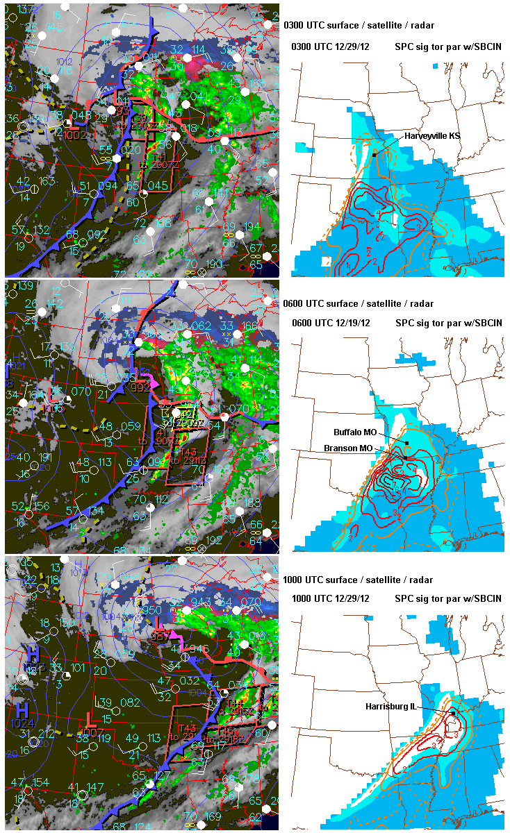
The last graphic above shows the evolution of the surface pattern and the tornado environment (as suggested by the SPC significant tornado parameter) during the night. Tornadoes occurred in southern Missouri near Buffalo (1 death) and at Branson, and also in southern Illinois with the deadly EF4 tornado at Harrisburg before dawn. Farther north from Kansas City eastward, storms finally outran the warm advection zone and moved into a more stable environment, eventually losing their severity.

Tonight and tomorrow (March 2nd) will likely see a repeat performance of tornadoes over southern MO and northern AR into the Ohio Valley with yet another weather system. People in those areas should be on the alert!

- Jon Davies 3/1/12