


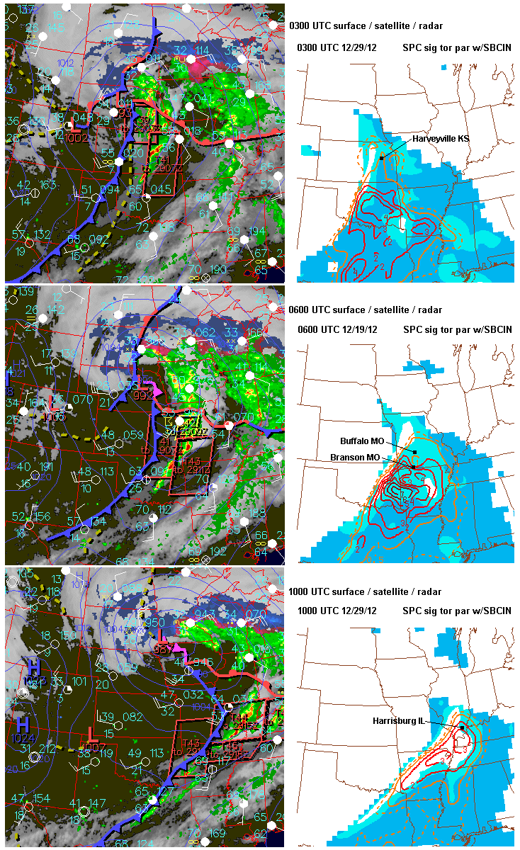
The tornado outbreak this past Tuesday evening into early Wednesday morning took several lives in Kansas, Missouri, and Illinois, and was an early reminder that spring is nearly here in the central U.S. Hardest hit was Harrisburg IL with an EF4 tornado killing 6 people around 5 am Wednesday morning. The first killer tornado (EF2, see damage photo above) hit around 9:00 pm the evening before, southwest of Topeka KS at Harveyville, claiming the life of one man who died later on Wednesday night.
This was a very difficult warning situation. The tornado only lasted about 4 minutes, but happened to go right down through the small town. Had the path been displaced a few miles north or south, we wouldn't have heard much about it. The parent supercell (see arrows on radar composite above) developed near Pratt KS more than 3 hours earlier, producing a brief tornado southwest of Hutchinson, but hadn't produced any other reported tornadoes for over 2 hours since that time. The rotational signature on radar at the time the tornado hit Harveyville was brief and small (see Topeka NWS radar images here). The Harveyville area had been under a severe thundertorm warning for about 30 minutes prior to the tornado.
A look at the meteorological setting shows that, even though CAPE was relatively "small" over east central and northeast KS (< 500-800 J/kg, see RUC soundings above), strong warm advection was occurring from the southwest. A comparison of NAM model temperature & moisture profiles from 6 to 9 pm near Emporia (see 4th graphic above) showed that warming and moistening was occurring in the lowest 1.5 km above ground, with cooling ongoing above that. This reduced a sharp temperature inversion that was present earlier, and changed the thermodynamic environment from "quasi-elevated" (most instability coming from air parcels originating well above ground) to one that was becoming more surface-based.
While never strongly surface-based as seen by the Emporia RUC soundings above (probably one reason the tornado was short-lived), enough low-level stability was being removed by the low-level warm advection in combination with very large low-level wind shear (storm-relative helicity over 600 m2/s2!) to sustain marginally surface-based updrafts that could briefly support a strong tornado. The fact that the parent supercell had been established for so long (3 hours) in flow of more than 80 kts aloft also likely helped the storm produce the tornado in a marginally surface-based setting. This is a reminder that long-lived supercells within a zone of strong warm advection and low-level shear should be watched carefully regarding tornado potential, even if the initial environment ahead of the warm advection looks rather "elevated" in nature.
The last graphic above shows the evolution of the surface pattern and the tornado environment (as suggested by the SPC significant tornado parameter) during the night. Tornadoes occurred in southern Missouri near Buffalo (1 death) and at Branson, and also in southern Illinois with the deadly EF4 tornado at Harrisburg before dawn. Farther north from Kansas City eastward, storms finally outran the warm advection zone and moved into a more stable environment, eventually losing their severity.
Tonight and tomorrow (March 2nd) will likely see a repeat performance of tornadoes over southern MO and northern AR into the Ohio Valley with yet another weather system. People in those areas should be on the alert!
- Jon Davies 3/1/12
No comments:
Post a Comment