Wednesday, March 24, 2021

Active March severe weather pattern continues across the central and southern U.S.!

After last week's St. Patrick's Day outbreak in the South on March 17 (more about that farther down), yesterday saw yet another cold-core type setting with tornadoes in west-central Illinois (photo above) and southeast Iowa, on top of last week's cold-core activity (see my last blog post here).

Tomorrow (March 25, 2021) will likely see another tornado outbreak in the southern Mississippi River Valley into parts of Mississippi, Alabama, Tennessee, and Kentucky.  This will probably be similar in scope to the March 17 outbreak with several large long-track tornadoes, so people living in those areas should monitor weather information carefully!

Yesterday's cold-core event was weak (2 EF0 tornadoes), but fairly classic pattern-wise, occurring in the vicinity of a Pacific cold front intersecting a warm front in the northeast Missouri (MO), west-central Illinois (IL), and southeast Iowa (IA) area east of a closed mid-level low.  That was unlike last week's cold-core activity in Kansas, Nebraska, and Missouri (see blog post here) when the tornadoes occurred along occluded sections of a frontal boundary near the mid-level low, instead of the more common Pacific front/warm front intersection area. 

Here's the 0000 UTC 3/24/21 surface map (7:00 pm CDT 3/23/21) shortly before the tornadoes yesterday:


The tornadoes occurred near Rockport, IL (photo at top of this page), and Ft. Madison, IA, marked on the surface map above, close to the Pacific cold fornt / warm front intersection as mentioned earlier, roughly matching the Fig. 16 composite in Davies (2006).

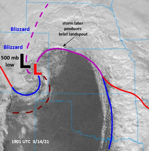
The visible satellite photo at the same time (tornadic cell locations at arrows) showed the cloud swirl associated with the mid-level closed low at 700 mb (roughly 10,000 ft MSL) and 500 mb (roughly 18,000 ft MSL):


The 12-hr 700 mb forecast from the NAM model morning run on 3/23/21 showed the mid-level low over southwest IA, and a broad area of cold air aloft well below freezing (the blue colors) spreading over the warm sector into western IL:  


With surface dew points in the mid-50's (deg F) near the warm front, that cold air aloft generated plenty of instability to support storms and some brief tornadoes.

The 9-hr HRRR model forecasts from mid-morning suggested the location of the Pacific front/warm front intersection fairly well from surface temperatures and winds (1st panel below).  Plentiful low-level CAPE (0-3 km, 2nd panel) was also forecast to surround the boundary intersection area and extend northward into southeast IA:


The low-level CAPE north of the warm front into IA may have been a contributor to the brief tornado with minor damage near Ft. Madison, IA that occurred some distance north of the warm front within a linear feature on radar (not shown), unlike the tornadic supercell near Rockport, IL.

Back on March 10 (2021), there was a cold-core setting that affected south-central Minnesota that was _not_ tornadic, although a photogenic supercell (not shown) occurred near the warm front in that case.  Several people have asked me why that setting did not produce tornadoes, and while I don't have definitive answers, comparing that evening's surface map with yesterday's surface map suggests some clues.

Notice on the 3/10/21 surface map at 2300 UTC (5:00 pm CST, shown below; location of tornado-warned supercell marked by circled "S") that the warm front was "bulging" much farther northward relative to the surface low:


As a result, comparing this map with the surface map earlier from yesterday, there was not much of a "spiraling" wind flow pattern into the surface low.  Instead, winds went from a south or south-southeast direction across southeast Minnesota and most of Wisconsin abruptly to a north or north-northeast direction in the area northeast of the surface low.  This was different than yesterday's surface setting (see the surface map shown earlier) where winds from the warm sector over Illinois and then flowing into the Iowa surface low (ignoring a few "outflow" locations) backed more gradually across the warm front and farther northwestward, going from southerly to southeasterly to easterly.  This more "spiraled" backing wind flow pattern into the surface low may have helped set up a better low-level shear environment for low-level rotation in yesterday's storms near and just north of the warm front.

I'll make one other observation comparing the two surface maps.  In the non-tornadic March 10 case, the temperature contrast across the Minnesota warm front was > 10 deg F in a short distance (say 10-15 miles), which would likely have a detrimental effect on low-levels for tornado potential with the supercell that was crossing the warm front that day.  Yesterday, the temperature contrast across the warm front and for miles north of it was rather gradual, only around 5 deg F between west-central IL and southeast IA, and would not have as abrupt an impact on storms crossing the warm frontal area.

Before I close, I wanted to talk briefly about last week's St. Patrick's Day tornado outbreak in the South.  It was well-forecast days in advance by SPC, announced aggressively in media, and there were  no deaths and only a few injuries in spite of 30+ tornadoes occurring!  The excellent forecasts and media coverage appeared to really contribute to the low injury toll and the lack of deaths.  I truly hope the same will be true with tomorrow's expected outbreak in some of the same area.

Briefly, regarding the 3/17/21 outbreak, here's the morning NAM model forecast at 500 mb valid at mid-afternoon, along with an inset of the NAM 0-1 km energy-helicity index (CAPE and low-level shear combined) for the same time:


The setting was fairly classic, with a strong trough moving eastward across the southern U.S., and "spreading" jet branches providing forcing for generating storms out ahead of the trough where CAPE/shear combinations were strong and very supportive of tornadoes across the broad warm sector in the Dixie states.   

Notice too, that there was yet another "cold-core" setting associated with the same system, this time over southwest MO, where some weak tornadoes occurred.

And getting back to the Dixie states, below are a couple images of a supercell and long-track tornado (note the horizontal vortex on the second image) that moved across southwest Alabama (see tornado track on inset in image above) at mid-afternoon.


It is a little unusual to be able to see such visible supercell structure in the South.

I hope people in the Dixie states and the southern Mississippi River Valley/Ohio River Valley areas pay careful attention to weather information tomorrow, March 25, 2021.  Stay safe!

- Jon Davies  3/24/21

Tuesday, March 16, 2021

March 13, 14, and 15 bring big tornadoes and cold-core action to the Plains


Friday, March 12 through Monday, March 15, 2021 saw tornado activity really ramp up in the Central Plains.  There were no deaths or injuries reported, as the biggest day (Saturday, March 13) was well-forecast and warned.

Over 10 tornadoes occured on March 13 in the central and southern Texas (TX) panhandle, including the twin large tornadoes pictured above from the same supercell near the town of Happy, along with a storm-relative velocity image at roughly the same time showing the two mesocyclones side by side.  The tornado and mesocyclone labeled "1" above generated a tornado rated EF2 on the ground for 17 miles according to NWS Amarillo (had the tornado hit a town, the EF rating would likely be higher).

Farther east, according to radar, it appeared there were also two tornadoes on the ground simultaneously at times with the Happy, TX supercell according to radar (not shown).  But these were not photographed as the storm became increasingly wrapped in rain and the radar circulations occurred in difficult spotter/chaser terrain northeast of the Palo Duro Canyon State Park.  It doesn't appear that there were any tornado mergers, but that's not entirely clear, and there were also times when multiple mesocyclones appeared to be interacting with each other (not shown).

The following two days, other localized tornadoes occurred in northwest Kansas (KS) and southwest Nebraska (NE), including the "white" landspout tornado pictured below (1st photo) west of Trenton, NE on Sunday March 14, and a tornado near Stilwell, KS, south of Kansas City (2nd photo) where some minor damage occurred (rated EF0):


I'll briefly touch on the meteorological setting for March 13, March 14, and March 15, as these days involved a closed 500 mb low within a large mid-level trough moving slowly northeastward from the southwestern U.S.  On March 13, the 500 mb low was too far to the west to be directly involved in the Texas tornado outbreak, but on the subsequent two days, the cold-core low aloft had a direct impact on tornadoes occurring in rather marginal settings.

Below is a visible satellite image at mid-afternoon on March 13, with surface weather map features drawn in, and the location of the 500 mb low well to the west:


The tornadic supercells occurred in the warm sector ahead of a Pacific cold front and south of a warm front over the TX panhandle, including the Happy, TX supercell (labeled with arrow).   Below are SPC mesoanalysis images of two composite tornado parameters, suggesting how favorable for supercell tornadoes the environment was over the panhandle at 2200 UTC (4:00 pm CST) while tornadoes were ongoing near and east of Happy, TX:


And here's an analysis sounding from the RAP model at Plainview TX (south of the Happy, TX supercell) at 2100 (3:00 pm CST) at about the time the outbreak started:


Notice that parameters such as mlCAPE (> 2000 J/kg), 0-1 km storm-relative helicity (SRH > 250 m2/s2), surface to 6 km shear (> 70 kt), and 0-3 km mlCAPE (> 150 J/kg) were all highly favorable in this environment for supercells capable of generating strong tornadoes.

The next day (Sunday, March 14), satellite with surface features (below) showed that the 500 mb low had moved to eastern Colorado (CO), where a blizzard dumping over 2 feet of snow was in progress over northern CO and southeast Wyoming.  The surface low had also evolved northward to eastern CO, with a massive dry slot/clear slot punching northward across most of Kansas with the 500 mb low, while the Pacific cold front had advanced eastward:


Along the occluded front extending northeastward from the CO surface low, the wind shift along the boundary combined with surface heating and CAPE (from the cold air aloft with the mid-level low) to help produce a couple of brief landspout tornadoes at early afternoon, including the Nebraska EF0 tornado pictured earlier.

An SPC image of 0-3 km mlCAPE and surface vorticity at 1900 UTC (2:00 pm CDT) showed very well the low-level CAPE (in red) overlapping the west-east boundary (blue surface vorticity lines) over northwest KS and southwest NE:

These are ingredients that can generate non-supercell tornadoes such as landspouts when low-topped storm updrafts from CAPE and heating phase properly with the boundary so that vertical vorticity along the wind shift can be stretched upward.

Here's a RAP model 1-hr forecast sounding near Trenton, NE  shortly before the brief NE tornado pictured earlier -- notice how the CAPE is relatively small but bunched low in the  atmosphere, typical of tornado settings near 500 mb lows:


And here's an image showing the crisp low-topped storms looking north from KS into NE associated with this occluded front and cold-core setting:


Last, here's the satellite/surface setting on Monday, March 15 between 2000 UTC and 2100 UTC (3:00-4:00 pm CDT) over the KS-Missouri(MO) area:


The 500 mb low had "split" or evolved into two centers, with one drifting east across Kansas and generating a surface low over northeast KS near the stalled occluded front.  With all the cold air aloft associated with the 500 mb low and the west-east boundary near Kansas City, the stage was set for a couple more brief tornadoes, including the one pictured earlier near Stilwell, KS.

The SPC depiction of low-level CAPE and surface vorticity at 2100 UTC showed a setting similar to the day before (low-level CAPE overlapping the boundary ), except this time near Kansas City:

And here's a RAP model 1-hr forecast sounding at Harrisonville, Missouri, shortly before the tornado at Stilwell, KS just west across the KS-MO border:

With a somewhat more clockwise-curving hodograph, the Stilwell storm appeared more supercellular on radar (not shown), but the components of low-level CAPE and the boundary were also likely significant contributors to the tornado in this occluded front and cold-core setting.

In the March 13, 2021 Texas case, parameters and ingredients were strong within the warm sector away from pre-existing fronts and boundaries to help generate several classic-type supercell tornadoes.  But on March 14 and 15 as the 500 mb low moved slowly out into the Plains, the tornadoes were more a result of low-topped storms interacting with an occluded front, where the boundary was a key factor.

It is interesting to note that the Texas twin tornadoes pictured at the top of this article occurred 31 years to the day after the twin Hesston-Goessel KS tornadoes that went on to merge together into an EF5 tornado.

And I must note that St Patrick's Day 2021 (tomorrow) will likely see a significant outbreak of severe weather and tornadoes in the South over the Arkansas-Louisiana-Mississippi-Alabama area.  I hope everyone in those areas stays informed and up-to-date on the weather.. stay safe!

- Jon Davies  3/16/21