
**** Note -- I added an important update at the bottom of this post on 6/1/16 ****
Most storm chasers count the number of tornadoes they see on any given day. The bigger the number, the more "impressive" a chaser you are, I guess. But many times, from a useful operational meteorological view, such "counts" are inflated.
Last Tuesday (May 24) near Dodge City is a good example. I've heard several storm chasers tell me they saw anywhere from 10 to 17 tornadoes on the prolific tornadic supercell that moved from near Minneola across Dodge City, thankfully missing any direct hits on towns.
My wife Shawna and I followed the storm starting from a distance (near Bucklin, Kansas) up to fairly close just south of Dodge City. I'm conservative regarding tornado counts, and we saw at least 4 "primary" tornadoes, each from its own mesocyclone cycle as new parent circulations developed north or east of each tornado, all fascinating to watch.
Any other tornadoes seemed to be brief and transitional, including a rope tornado in the inflow to the 2nd primary tornado. One of the mesocyclones just SW of Dodge City produced several visual "spin ups" with occasional multiple vortices before putting a fully condensed tornado on the ground. But from a practical viewpoint, I would count that as one intermittent tornado circulation (again, same mesocyclone) instead of several individual tornadoes.
Following is documentation of what we saw using video captures (some of these contrast enhanced to make it easier to see features). All views are toward the west-northwest or northwest.
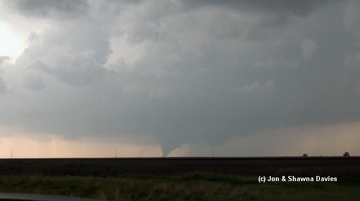
Not counting any brief early touchdowns we couldn't see, here's the first primary tornado touchdown northwest of Minneola, viewed from near Bucklin (25 miles away!) around 6 pm CDT, along with a wide view of the storm (Bill and Anna Stromberg were in the vehicle ahead of us):


Here's the "rope-out" phase of this first tornado, followed by an image that shows where the 2nd primary tornado soon would form:


When the new tornado formed, a thin rope tornado was visible in its inflow stream (see 2nd photo below). Meanwhile, the primary tornado became large but was in poor contrast when viewed from the southeast:


Here's the "rope-out" phase of this 2nd primary tornado, which was on the ground around 15 minutes. Notice a new mesocyclone again to its north or northeast, with a new tornado forming. This new tornado was hard to see (again, poor contrast), did not appear to last that long, and seemed somewhat transitional in nature. So I don't know whether it would be considered a "primary" tornado:


During this phase after the "transitional" tornado dissipated, it was hard to tell if the associated mesocyclone was splitting or just elongating eastward closer to Highway 283. Here's a photo Shawna took:
As we drove closer, the lighting improved, and rapid rotation from this mesocyclone was evident, soon resulting in dust whirls and multiple vortices under a low ragged cloud base.


Fortunately, the elongating tornado moved west of Dodge, while the new mesocyclone dropped a new tornado (the last primary one) north of the town (notice Dodge City and the storm chaser/truck traffic in the foreground):


This last tornado appeared to be on the ground for 5-8 minutes or so, after which we lost sight of it as heavy rain from another storm overtook us from the south around 7:15 pm CDT:

So, based on what we could see with this supercell, there were 4 primary tornadoes on the ground for more than 5-10 minutes each, which seems to agree generally with the map NWS Dodge City put on their web site:

We also saw one peripheral tornado in an inflow band, and one transitional tornado during a mesocyclone evolution phase that was difficult to assess, making 6 total for my conservative count. I don't doubt that there were other brief peripheral or transitional tornadoes that one could count differently, but the 4 primary ones we saw appeared most significant. Sadly, the tornado that passed just west of Dodge City damaged several homes and resulted in 2 injuries.
This event was also notable for the circus of chasers, storm tours, and local traffic jamming up Highway 283 south of Dodge City. One tour van nearly ran over my wife when they abruptly pulled off the highway, even though she was standing well off the road. I'm pretty upset about that, and clearly the traffic issue continues to increase the danger of storm chasing.
If I get time in a few days, I'll post something about the meteorology of this severe event.
Jon Davies - 5/30/16
Update on 6/1/16:
After viewing responses and photos from several other chasers, I clearly need to update my observations/opinions above.
I'll use Dave Lewison's excellent images from Facebook to highlight the changes... here's his Facebook photo link that you should check out. He was farther north on Hwy 283 and in better lighting conditions than Shawna and I were. On a couple of his images re-posted and labeled here, I've inserted/referenced small images from my original post to roughly indicate the corresponding features and phases.
First, when the 2nd primary tornado was on the ground west of Hwy 283, the rope tornado I originally called an "inflow band" tornado was actually a tornado from a new mesocyclone:

Second, shortly after this image, 2 rope tornadoes or vortices were visible under this new mesocyclone northeast of the 2nd primary tornado (I missed these), suggesting that there might have been 3 tornadoes on the ground for a short time:

Third, these appeared to morph into a somewhat larger rope tornado northeast of the 2nd primary tornado that we could not see from farther south in poorer lighting conditions:

And last, when the 2nd primary tornado "roped out", this larger rope tornado became a sizable and probable primary tornado (not a "transitional" tornado as I originally characterized it) while yet another new mesocyclone was forming to its east or northeast:

I don't know how long this new primary tornado lasted because we were fighting traffic and dealing with Shawna's tour bus encounter. But it seems clear from Dave's photos that this was a separate mesocyclone/tornado cycle of its own starting with the earlier rope tornado(s) northeast of the 2nd primary tornado, and not a short "transitional" phase as I characterized it in my original post.
Given this new information, I'd probably update the number of primary tornadoes on the Dodge City NWS map to 5 as follows, changing the "?" to number 3, and moving what I'd shown as numbers "3" and "4" to numbers 4 and 5:

With the new information above, I would probably up my conservative tornado "count" (not that important, and only an opinion!) to 7 tornadoes, and maybe 8 depending on how one might view/interpret things. But certainly, I don't intend that to be definitive, and my original post wasn't meant to ruffle feathers. I only intended to get some discussion going about a fascinating event.
Thanks to Dave Lewison for his images, and for the responses and additional helpful information from several chasers on my wife's Facebook page!
Jon Davies - 6/1/16


