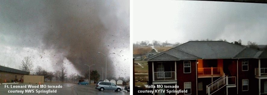
Killer tornadoes in Missouri are somewhat rare during the month of December, but do happen (5 such events since 1950 prior to 2010). Last Friday's tornado outbreak that left 4 dead in central MO (in addition to 3 dead in northwest AR) was also rare in that the Missouri tornadoes occurred at mid morning (see photos above at Ft. Leonard Wood and Rolla). Another interesting aspect of the outbreak was its evolution from a complex beginning with 2 supercells close to each other in eastern OK into a bow echo structure over eastern MO, persisting for over 6 hours through parts of OK/AR/MO/IL.
 The 2nd and 3rd graphics above are regional radar reflectivity composites showing the broad evolution of this complex from 2 distinct long track supercells (circled in white) around 1200 UTC/6 a.m. through 1600 UTC/10 a.m., toward merging into a bow echo type structure after that, with several embedded tornadoes in the St. Louis area around noon. Locations of some stronger tornadoes (EF2+) and deaths are indicated on these graphics. Some of the tornadoes in the latter stages of this complex may have been bow echo/QLCS tornadoes associated with mesovortices instead of deeper mesocyclones. At any rate, this is an interesting example of an event metamorphasis from quasi-discrete supercell mode to a more linear or bow echo mode with embedded tornadoes continuing during both modes.
The environment ahead of the large upper trough (not shown) generating the storms was a classic "small CAPE/large shear" setting so common with winter tornado events. The RUC sounding analysis for 1500 UTC (9 a.m.) at West Plains MO (UNO, see 4nd graphic above) during the hour before the Ft. Leonard Wood and Rolla tornadoes (both from northern supercell, 2 deaths) and Lecoma MO tornado (southern supercell, 2 deaths) showed this, with massive low-level shear and a very large clockwise-turning hodograph/wind profile in the lowest 1 km. Total CAPE of only 400-600 J/kg (620 J/kg sfc-based CAPE) in a close-to-saturated low level environment with little or no convective inhibition (CIN) was more than enough buoyancy to support strong supercell updrafts and deadly tornadoes in such a highly sheared environment.
Composite supercell tornado parameters sometimes have problems working well as indicators in such small CAPE environments. The last graphic above shows the significant tornado parameter (STP, effective shear version) along with radar and surface features around the time tornadoes were occurring in the St. Louis area; notice that not much "sig tor threat" was explicitly indicated over Missouri. Conditional sig tor probabilities (same graphic, same time, developed by Bill Togstad using one of my RUC sounding databases) suggested more tornado potential in the St. Louis area, probably because Bill's equation seems somewhat more "tuned" toward detecting smaller CAPE settings with potential for tornadoes, a nice characteristic, but also one that can sometimes increase false alarms in marginal situations.
At any rate, such a prolific, persistent, and mode-evolving complex (6 hrs+ life span, 7 total deaths) is a rather rare event in the Missouri area, particularly on New Years Eve Day! More survey information can be found at NWS Tulsa, NWS Springfield, and NWS St. Louis sites.
- Jon Davies 1/5/11