Thursday, March 1, 2012

Harveyville KS February 28, 2012 - a difficult tornado warning situation


The tornado outbreak this past Tuesday evening into early Wednesday morning took several lives in Kansas, Missouri, and Illinois, and was an early reminder that spring is nearly here in the central U.S. Hardest hit was Harrisburg IL with an EF4 tornado killing 6 people around 5 am Wednesday morning. The first killer tornado (EF2, see damage photo above) hit around 9:00 pm the evening before, southwest of Topeka KS at Harveyville, claiming the life of one man who died later on Wednesday night.

This was a very difficult warning situation. The tornado only lasted about 4 minutes, but happened to go right down through the small town. Had the path been displaced a few miles north or south, we wouldn't have heard much about it. The parent supercell (see arrows on radar composite above) developed near Pratt KS more than 3 hours earlier, producing a brief tornado southwest of Hutchinson, but hadn't produced any other reported tornadoes for over 2 hours since that time. The rotational signature on radar at the time the tornado hit Harveyville was brief and small (see Topeka NWS radar images here). The Harveyville area had been under a severe thundertorm warning for about 30 minutes prior to the tornado.

A look at the meteorological setting shows that, even though CAPE was relatively "small" over east central and northeast KS (< 500-800 J/kg, see RUC soundings above), strong warm advection was occurring from the southwest. A comparison of NAM model temperature & moisture profiles from 6 to 9 pm near Emporia (see 4th graphic above) showed that warming and moistening was occurring in the lowest 1.5 km above ground, with cooling ongoing above that. This reduced a sharp temperature inversion that was present earlier, and changed the thermodynamic environment from "quasi-elevated" (most instability coming from air parcels originating well above ground) to one that was becoming more surface-based.

While never strongly surface-based as seen by the Emporia RUC soundings above (probably one reason the tornado was short-lived), enough low-level stability was being removed by the low-level warm advection in combination with very large low-level wind shear (storm-relative helicity over 600 m2/s2!) to sustain marginally surface-based updrafts that could briefly support a strong tornado. The fact that the parent supercell had been established for so long (3 hours) in flow of more than 80 kts aloft also likely helped the storm produce the tornado in a marginally surface-based setting. This is a reminder that long-lived supercells within a zone of strong warm advection and low-level shear should be watched carefully regarding tornado potential, even if the initial environment ahead of the warm advection looks rather "elevated" in nature.

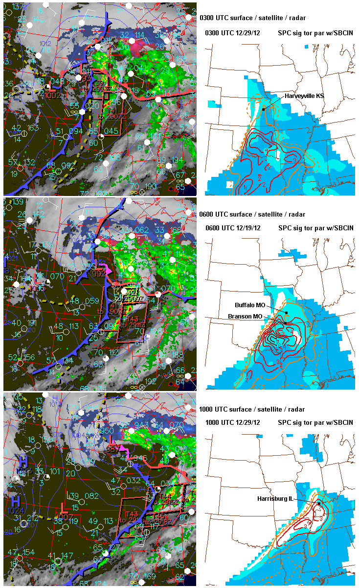
The last graphic above shows the evolution of the surface pattern and the tornado environment (as suggested by the SPC significant tornado parameter) during the night. Tornadoes occurred in southern Missouri near Buffalo (1 death) and at Branson, and also in southern Illinois with the deadly EF4 tornado at Harrisburg before dawn. Farther north from Kansas City eastward, storms finally outran the warm advection zone and moved into a more stable environment, eventually losing their severity.

Tonight and tomorrow (March 2nd) will likely see a repeat performance of tornadoes over southern MO and northern AR into the Ohio Valley with yet another weather system. People in those areas should be on the alert!

- Jon Davies 3/1/12

Tuesday, February 21, 2012

Cold-core system on 2/20/12 - 1 dead but no tornadoes


Yesterday's cold-core system (President's Day 2/20/12) with an elongated 500 mb low crossing Nebraska didn't produce any tornadoes, but sadly caused 1 death as straight-line thunderstorm winds farther south toppled a mobile home near Ada, Oklahoma. Shawna and I, along with photographer Stephen Locke, traversed the system driving back to KC on I-70 after the Denver Storm Chaser convention, enjoying the sight of February cumulus towers and some low-intensity storms near the wind farms west of Salina, Kansas.

It's hard to get tornadoes in the Plains in February, even with cold-core systems, so our expectations were low. This system and one that produced several weak tornadoes in central Nebraska last May 12 make an interesting comparison regarding tornado potential.

From the visible satellite photos above that compare both systems at early to mid afternoon, the 2/20/12 system showed little visual evidence of a closed mid-level low (too elongated and linear), and low clouds were socked in around the south-central Nebraska surface low, limiting surface heating. In contrast, the 5/12/11 system showed easy-to-see spiraled cloud patterns around both the mid-level low and surface low, with several boundaries and plentiful sunshine evident over central and southeast Nebraska providing heating and boundary focus for storms and rotation just east of the Nebraska surface low. The elongated nature of the 2/20/12 mid-level and surface lows (compare those with the more circular patterns on the 5/12/11 SPC 500 mb & surface graphics above) could not properly bring into juxtaposition the necessary ingredients and focus for supporting tornadoes (sunshine, CAPE, well-defined boundaries, and low-level shear spiraling into the Nebraska surface low). The afternoon surface analysis above also showed a strong cold front yesterday catching up with the surface dryline over northern Kansas, squeezing off needed sunshine and surface heating over that area and southern Nebraska. Meanwhile, very cold air and energy aloft surging eastward at 700 mb around the bottom of the elongated mid-level trough over southern Kansas and Oklahoma (see last SPC image above), along with sunshine and surface heating in that same area, triggered moderate to occasionally strong linear storms over southern Kansas and central Oklahoma.

When considering tornado potential with cold-core systems, circular/spiraled mid-level and surface wind and pressure patterns win out just about every time when tornadoes do occur.

- Jon Davies 2/21/12

Thursday, February 2, 2012

Tornado forecasting classes at ChaserCon 2012


As was announced on the ChaserCon 2012 website last month, I'll be teaching 2 tornado forecasting classes on Friday evening , Feb. 17 at ChaserCon in Denver.

The first class deals with Basics (surface maps, upper air maps, and computer model forecasts, from 7:00 pm to 8:45 pm), and the 2nd class is Advanced material (including skew Ts and hodographs, from 9:00 pm to 10:45 pm). Enrollment in advance is required (you also need to be registered for ChaserCon to attend), and each class is $15.00 individually, or $25.00 for both (CASH only at the door, NO CHECKS!).

We're getting close time-wise, and class enrollments are filling up, so send an e-mail to Roger Hill at rogerehill@earthlink.net or to me directly at davieswx@gmail.com to enroll. Please specify which class you will be attending (Basics, Advanced, or both)

Tim Vasquez from Norman OK has taught the forecasting classes in the past. Even though he's not teaching this year, he will have a vendor table at ChaserCon to sell his forecasting books and materials, which are excellent storm chasing resources. Tim also continues to do chase forecasting classes in Norman, another great way to learn about severe weather forecasting! So if you are going to ChaserCon, stop by his vendor table and check out his stuff! Or, check out his web site at www.weathergraphics.com

See you at ChaserCon!

Jon Davies - 2/2/12

Monday, January 23, 2012

First tornado deaths of 2012 in Birmingham AL area on 1/23/12


A large deadly tornado (at least EF3 intensity) struck the Birmingham AL area early this morning around 4 a.m. CST (1000 UTC, Monday 1/23/12), killing at least 2 people according to media information at early afternoon.

The weather environment was primed for generating significant tornadoes before sunrise on Monday in Alabama. A RUC analysis sounding at 1000 UTC (see above) at Birmingham while the tornado was moving through showed a massively large wind profile (hodograph) with nearly semi-circular curvature, ideal for generating low-level rotation in storms when notable instability is also present. In this case, there was around 700 m2/s2 of storm-relative helicity, with mixed-layer CAPE between 1000 and 1500 J/kg, putting the storm environment in a statistically dangerous area on an SRH-CAPE diagram (see red dot on scatterdiagram above) regarding support for strong or violent tornadoes. Compared to last Saturday's environment with severe storms in central Georgia (1/21/12, not shown) where representative SRH values were around 300 m2/s2 and CAPE was only 300-400 J/kg, this was a much more dangerous and life-threatening setting.

The overnight SPC mesoanalysis also suggested potential for significant tornadoes (see the 0900 UTC SPC graphics above), with large SRH-CAPE combinations indicated in the same area where storms were moving through. A strong negatively-tilted trough at 500 mb (roughly 18,000 ft MSL, see last chart above) prompted the deadly severe weather, pulling deep moisture into Alabama from the Gulf of Mexico, generating strong low and mid-level wind fields, and providing strong lift and forcing.

Given that it was still dark when the Birmingham area tornado moved through, the death toll could have been much larger. It surely helped that the storm potential was well-outlooked by SPC already on Sunday, and NWS warnings in the area were timely.

Jon Davies - 1/23/12

Thursday, January 12, 2012

11 Jan 2012 "surprise" tornadoes in North Carolina


Yesterday's EF2 tornadoes in Rutherford and Burke counties of western North Carolina (see photos above) injured 10-15 people (one critically) and came as a bit of a surprise. This case is a good example of how difficult it is to forecast winter-time tornadoes. Instability (CAPE) is often small (around 500 J/kg or less), but wind shear and low-level storm-relative helicity (SRH) are often large (> 200-300 m2/s2); that makes it hard to assess when CAPE and SRH combinations are truly strong enough to support significant tornadoes. It's just as important to assess the strength and focus of the accompanying synoptic setting and how the CAPE/shear environment fits with that.

Wednesday's system (1/11/12) had been a mid-level cut-off low over Texas the previous day (1/10/12, see NAM 500 mb vorticity charts above), and was being pushed rapidly into the Carolinas by a larger wave at 500 mb digging into the Central Plains. Note that although Wednesday's upper system over the Southeast was no longer a closed low, it was now a tight and dynamic short wave with a strong vorticity max moving into the western Carolinas (red area and "X", see arrows), focusing upward forcing. This strong upper wave and vorticity max had also caught up to the associated surface front (blue curved line), addiing to the strong dynamic focus in the western Carolinas area. (The previous day, the same upper vorticity max located in Texas had lagged the surface front in Mississippi by some distance.)

The fixed-layer Sig Tor Parameter at 2100z (STP at 4 pm EST, see SPC mesoanalysis chart above) suggested a marginally favorable environment (> 1.0) for tornadoes over NW South Carolina inching into SW North Carolina, just ahead of the strong upper vorticity center seen earlier and the surface front, near the "triple point" where fronts met (see surface inset). These dynamic factors and environment provided enough focus for the south end cell of a broken arc of low-topped storms (see visible satellite image above) to become a damaging tornadic supercell as it moved into North Carolina.

A similar setting the day before over Mississippi, but with somewhat less focus and slightly less favorable STP values (not shown), did not generate any tornadoes, illustrating how subtle and difficult winter tornado settings with small CAPE can be to assess, in contrast to days like the Joplin tornado where CAPE exceeded 4000 J/kg. Again, an awareness of how synoptic features come together or focus into a particular area (e.g., strong short wave and vorticity max, frontal orientation relative to those features, along with prefrontal environment) is important. Typically, STP or EHI values slightly larger than 1.0 aren't impressive, but the surface and upper-air dynamic focus in this case suggested more attention.

A 2200 UTC RUC-estimated sounding at Shelby NC, about 20 minutes before the first tornado, is shown in the last graphic above. Notice that the CAPE was small (< 500 J/kg), but the SRH moderate to strong (260 m2/s2). With all the CAPE "compressed" below 400 mb (approximately 24,000 ft MSL), rapid supercell updraft accelerations may have been enhanced in low-levels, even though total CAPE was relatively small, helping with tilting and stretching of streamwise vorticity associated with SRH in the environment.

Jon Davies - 1/12/12

Saturday, December 31, 2011

The 2011 tornado death toll - 2nd worst in U.S. history!


Here we are on the last day of 2011, and the U.S. tornado death toll for the year is at least 552, tied with 1936 as the 2nd deadliest U.S. tornado year! (The number of deaths may be even higher depending on how one categorizes them; the city of Joplin lists 161 tornado deaths for the May 22nd tornado instead of the National Weather Service "official" number of 158 deaths, probably due to how NWS categorizes some deaths as "direct" vs "indirect".)

I don't think most people who hear this in passing on TV comprehend how huge this is. In this day and age, that number is incredibly sobering! (See how dramatically 2011 stands out in the chart above among the last 50 years of U.S. tornado deaths.) Many of my colleagues, myself included, thought we would never see such huge death tolls again with the warning systems that are now in place in our country.

Given the violent tornadoes in 2011, without our warning systems, the death toll in 2011 would certainly have been worse. But I also think things could be better. The NWS assessment from Joplin earlier this year concluded there is considerable "desensitization" to warnings in our population from perceived overuse of sirens and warnings.

There obviously aren't easy answers. Some quick random thoughts with the new year upon us:

- Continued and ongoing public education is clearly needed about the importance of severe weather awareness and safety.

- Though not talked about much, siren policies across the country could be more standardized and less confusing... there are big inconsistencies regarding how sirens in different areas are used and activated. For example, some cities such as Joplin run them in shorter 3-minute bursts and then stop (as on the Joplin tornado day) which can be confusing to people in the most dangerous situations (when the sirens stop, is the danger past?), while other cities run them longer. And in many metro areas, sirens tend to be an all or none proposition until technology is installed to activate them only for localized areas directly threatened by an approaching tornado. Siren policies and equipment (as well as the NWS interface with those who activate them) appear to need closer examination and standardization between local governments so we don't inadvertantly train our citizens to ignore them due to a perceived "cry wolf" factor.

- If the NWS endorses use of "tornado emergency" statements to alert populated areas of imminent danger to life, then they can be more consistent in using them. If there was ever a situation that cried out for a tornado emergency statement conveying increased urgency, it was Joplin last May 22nd where 161 people died. But none was issued. By around 5:38 pm when the tornado was entering Joplin (about 20 minutes after a standard-worded "radar-indicated" tornado warning and 3 minute siren burst), there was enough information from radar and spotters to quickly issue a strongly-worded tornado emergency statement for local Joplin media, adding urgency and emphasis in a dangerous life-threatening situation. This would have been timely enough to possibly save some additional lives in spite of the hard-to-see and rapidly-developed violent tornado. The tornado warning was reissued at 5:48 pm with much stronger wording, but why wasn't an urgent tornado emergency statement issued 8 to 10 minutes earlier?

I hope some lessons from last year's tornado disasters (unprecedented for our modern technological age) result in growth and learning for all of us, as well as better tools and preparedness in 2012.

Jon Davies - 12/31/11

Wednesday, November 30, 2011

Don Harman


Some extremely sad news today... Long-time Kansas City meteorologist and weathercaster Don Harman died yesterday. He worked at WDAF-TV since 1999, and was very popular on their morning show.

Don had an awesome sense of humor, both on-air and off. He was always enthusiastic about weather, very knowledgeable, and a great communicator. My wife Shawna and I always enjoyed watching him on TV, as well as seeing him at AMS meetings, and have fond memories of the time a few years ago when he interviewed us about our kids book on storm chasing. He was a friend, and we are quite taken aback today at his passing.

With all the posts and discussion Shawna has been monitoring today on Facebook, it is clear that Don was an important part of KC area mornings for many many people, and will be missed beyond words. No one can replace him.

Our hearts and thoughts go out to Don's family and little girl, as well as the staff at WDAF. I can't imagine what they are feeling right now. This is a huge loss...

- Jon Davies 11-30-11