Thursday, April 7, 2011

An Essay: Gustnado or Tornado?


My analysis (previous blog post) of the setting for Sunday's "gustnado" on 4/3/11 near Perry KS stirred up different reactions and opinions as to whether Sunday's vortex actually was a "tornado" or not. Nature certainly defies categories made by man, and there are definite gray areas in classifying tornadoes and small-scale atmospheric vortices.

Sunday's "gustnado" was not associated with a mesoscyclone. But a "landspout" (a non-supercell _tornado_ according to the AMS glossary) isn't associated with a mesocyclone, either, and is considered a tornado because the vortex (along a nearly stationary or slow-moving boundary) extends well up into the cloud of the parent thunderstorm, with dust typically extending in a vertical column all the way to cloud base, often under a condensation funnel aloft. Gustnadoes always occur along thunderstorm gust fronts and are more shallow; the AMS glossary definition also categorizes them as "weak" and "short-lived".

To my way of thinking, landspouts and gustnadoes are somewhat similar: They both develop from vertical stretching of an area of slow "spin" or vorticity along a boundary, tightening that into a stronger more well-defined vortex. More prolific landspout and gustnado days also feature a steep lapse rate near the ground that enhances vertical stretching as a result of strong surface heating, similar to days where multiple dust devils form over dirt fields from rapidly rising thermals.

The main difference between landspouts and gustnadoes seems to be the depth of the circulation, and the type of boundary they develop on. True landspouts (one type of non-mesocyclone tornado) tend to develop with thunderstorms on pre-existing stationary or slow-moving wind shift boundaries that are somewhat more "straight" in the vertical where the tightening circulation can extend to greater depths and last sometimes for tens of minutes. In contrast, gustnadoes always develop on gust fronts, typically faster moving boundaries that are more "curved/sloped" in the vertical, so that the tightening circulation can't extend/stretch as deep and is more transient as the gust front moves/advances. See the diagram above that attempts to illustrate this difference.

But.... what if there is a gust front that is not particularly fast-moving and maybe doesn't have so much vertical slope? What if a circulation that develops and stretches on that gust front persists for more that a minute or two, lasting maybe 5 minutes or more? What if it occurs under a high cloud base (for example, above 2000 meters) where it is difficult to see how far the circulation extends upward? What if the circulation becomes rather intense (winds to EF1 intensity) and destroys a small farm building? Do we call this a "tornado"? What exactly is "shallow" and "not shallow", according to the subjective AMS definition?

In 2006, on May 23rd, an "outbreak" of gustnadoes occured along the gust fronts associated with a squall line from southeast South Dakota to south-central Nebraska, with many photos taken by chasers. Dirt from some of these extended dramatically to cloud base, with cloud circulation sometimes visible in the shelf above them (see Verne Carlson's photo above). NWS Sioux Falls called some of these vortices "tornadoes" in their local storm reports, while NWS offices in Nebraska did not (look up the SPC storm report log for 5/23/06). Here's another situation the same year, April 24, 2006: A supercell storm produced a mesocyclone tornado near El Reno, Oklahoma. Then, a few minutes later, a non-mesocyclone tornado occurred south along the supercell gust front (see Aaron Kennedy's photo above), which, with little temperature contrast, was barely moving and oriented more "vertical" than "sloped". This tornado had a well-defined condensation funnel with dirt extending upward to it and the clear appearance of a "landspout", even though it was technically on the storm's gust front.

From the above, you can see where man-made definitions and categories fail us, and how difficult it is in some situations to decide how to categorize an atmospheric vortex associated with a thunderstorm. I'll certainly admit that there may be a gray area about how to "categorize" Sunday's vortex. The apparent processes involved with the location of the circulation on a rather fast-moving gust front argue for calling the vortex a gustnado. But the high cloud bases and inconclusive photography regarding how far the vortex really extended upward in the vertical also muddy the waters regarding classification. So there's not a clearly definitive "answer", and we may have to accept that.

With the vortex persisting for awhile and doing some damage, I can see the desire to call such a vortex a "tornado", and I can't completely argue against that. If that were the only criteria, several "gustnadoes" this author has seen and reported were really "tornadoes". Had there been other tornadoes that captured the video spotlight on Sunday that were clearly supercell/mesocyclone in nature, I doubt that discussion would be so focused on this issue right now. For storm chasers, it is always more impressive to see what is categorized as a "tornado" than what NWS calls a "gustnado".

Arguing about how to categorize Sunday's vortex maybe misses the real point. Sometimes, there just aren't exact clear-cut answers, and nature certainly doesn't care what we call something. Perhaps we should just be aware and recognize that there are a wide variety of atmospheric vortices that we don't fully understand or know how to categorize exactly. For research meteorologists, my wife calls this "job security" :-).

- Jon Davies 4/7/11

Tuesday, April 5, 2011

Big gustnado near Perry KS on 4/3/10 - not a tornado!


Sunday's (4/3/10) storms over northeast KS featured a supercell that developed near Manhattan around 6 pm CDT (2300 UTC) north of a surface front. There was enough of a "cap" present that it took northward lift over the frontal surface to initate storms, even with temepratures near 90 F south of the front. As the Manhattan supercell passed N of Topeka and moved into Jefferson County northwest of Lawrence, the gust front extending south of the cell managed to tap very warm surface air south of the front, and a large well-organized gustnado (see photos above at top) formed near the intersection of the surface front and gustfront, east of Perry KS and well south of the supercell's mid-level mesocyclone.

Scott Blair has excellent photos and analysis at www.targetarea.net/apr311.html, and NWS Topeka has a good discussion here.

The large gustnado (a relatively shallow gust-front vortex compared to a tornado; see diagram above) probably would not have happened if the supercell gust front had not been able to access the steep low-level lapse rate air south of the surface front. On the radar images above (and a radar loop on the Topeka NWS site), you can see where the supercell was intially all north of the surface front. But as it moved east, the extreme south end along the gust front began to pull in true surface-based air near the frontal boundary-gust front intersection. Note that the observed sounding at Topeka prior to 7 pm CDT (0000 UTC, see skewT graphic above), before both the surface front and gust front passage, showed a very steep temperature drop off in the lowest 2-3 km, a lapse rate that meteorologists would call nearly "dry-adiabatic". Such lapse rates are associated with dust devils and rapidly rising thermals on hot sunny days. In this case, it appears that this air helped with low-level stretching along the gust front near the boundary intersection area, creating a rather intense vortex on the gust front.

Note on the radar image above that the gustnado location was well removed from the mid-level mesocyclone area of the supercell to the north (the wide video image by Connor McCreary above also shows the shallow gustnado occuring along the flanking line/gust front). I've heard some people online claim this to be a "true" tornado, but real understanding of the cell's geometry shows that it was _not_ a tornado, according to accepted definitions of gustnadoes. Gustnadoes can also often occur on days with LCL heights above 1600-2000m (like on 4/3/10), while true supercell tornadoes generally do not.

I've also heard some people claim Sunday's gustnado was definitely a "tornado" because it had multiple vortices. Well... that means nothing; many gustnadoes have multiple vortices. See the last set of images above taken on a storm chase south of Lubbock last June 14th with my wife Shawna and also Anna and Bill Stromberg. Dozens of gustnadoes occured along a storm gust front that hot Texas day, including some with multiple vortices (see the first 6/14/10 photo by Anna and Bill). Some of the gustnadoes were relatively large, too, with organized rear inflow jets, as can be seen in the 6/14 images.

This particular gustnado on 4/3/10 was large enough and well-organized enough to do some damage, and has certainly gotten plenty of air play on TV in view of the lack of real tornadoes that day. Gust front vortices can be very interesting!

- Jon Davies 4/5/11

Wednesday, March 23, 2011

3-21-11 and 3-22-11 storm forecasts - the "cap" made so much difference!


With a big trough in the west ejecting waves of energy into the Plains early this week, at first glance, both Monday 3-21-11 and Tuesday 3-22-11 all looked to be possible severe weather days over the KS/NE/MO/IA area. But the "cap" (warm temperatures advecting/moving northeastward from the desert southwestern U.S. in southwesterly flow aloft, called the "elevated mixed layer" or EML) made all the difference between the 2 days. Monday was a bust, with the EML completely inhibiting surface-based thunderstorm developing. But a strong wave in upper flow on Tuesday quickly eroded the EML and allowed storms to fire, some becoming tornadic over Iowa (see pics above from my storm chase with Shawna on Tuesday in the Bridgewater-Greenfield, Iowa area)

When looking at model forecasts for upcoming days, 700mb temperature forecasts can be useful in gaging when the "cap" may be too strong for storms to form. I like to use the chart above as a very rough guideline east of the high plains. In March, 700mb temperatures around 5 deg C (see the chart) are usually warm enough to completely inhibit storm development, unless one is in the high plains with a moist easterly upslope wind to provide mechanical lift (for example, last Saturday evening 3-19 around Lubbock TX - not shown -, where a couple supercells formed), or daytime temperatures become unseasonably warm (for example, 90's F).

The first 700mb forecast graphic above shows NAM and RUC forecasts for Monday evening (00 UTC 3-22-11) from the UCAR online site. Notice how temperatures 5 deg C and warmer on both models were forecast to extend all the way to the NE/SD border, blanketing the central plains in warm air aloft. As a result, Shawna and I did not chase on Monday, with MLCAPE all "tucked" in under this warm air aloft. No daytime storms formed across the KS/NE area due to this strong cap, even though appreciable MLCAPE was present south of a warm front (see the first panel of Earl Barker's RUC CAPE forecast graphic above at the same time). The 2nd 700 mb forecast graphic above shows NAM and RUC forecasts for Tuesday evening (00 UTC 3-23-11) that were dramatically different from the day before, with a strong upper wave moving through the plains, removing the "cap" over KS/NE/IA as much cooler temperatures aloft poured in (notice how the 5 deg C line was forecast to move well southeastward from the day before). This energy and cooling aloft easily triggered thunderstorms in northern KS and eastern NE during the afternoon that moved eastward into Iowa where combinations of MLCAPE (see the 2nd panel of Earl's RUC CAPE forecast above) and low-level shear (not shown) were favorable to support a few tornadoes.

Use the 700 mb temperature chart above as only a rough guide, and not a hard and fast rule. The most helpful thing is to watch _trends_ (for example, how the temperatures around 5 deg C and above moved out into the plains and increased aloft on Sunday 3-20 and Monday 3-21 on model forecasts, then retreated again with the approach of the strong wave on Tuesday 3-22). And don't think that temperatures cooler than the guidelines in the chart mean that storms will defintely occur! On Sunday 3-20 (not shown), 700 mb temperatures cooler than 4-5 deg C were over northern MO and IA, but storms did not develop along a weak frontal boundary. This was probably due to subsidence (sinking motion) behind a short wave that had moved across the Midwest earlier in the day, and boundary layer moisture that was not that deep or rich.

Hopefully the above helps some chasers be more aware of the trending of temperatures aloft and the "cap"/EML over the plains... that can really impact storm potential.

- Jon Davies 3/23/11

Friday, March 4, 2011

ChaserCon Forecasting Class, an Oscar-winning Storm Chaser, & New Book on the 1966 Topeka Tornado


Wow... tonight it has already been 2 weeks since I taught a tornado forecasting class for the first time at the National Storm Chaser Convention (ChaserCon) in Denver (see pic of me above). It was fun to do, well-received and well-attended (110 people), and I've had several attendees ask about access to some of my Powerpoint slides. I've managed to whittle down the presentation and put a subset of the slides online. If you were one of the people who paid to take my class, send me an e-mail at davieswx@gmail.com, and I'll direct you to the URL address where you can find these.

On another subject, Bill and Anna Stromberg are good friends who work in the film music business in the LA area, and they love to storm chase. Amazingly, Bill's brother, production/art designer Robert Stromberg, won his 2nd Oscar in a row last Sunday night for his work on last year's Alice in Wonderland ! Bill and Anna's storm chasing bug has caught Robert a bit, who was kind enough to share his photos through Bill on this blog last November when he was the only one to document what looked to be a rare morning tornado near Bakersfield CA. Go back and check those pics out here. Congratulations on your Oscar win, Robert!

Last but not least, on Wednesday night 3/2/11, our Kansas City AMS chapter had author Bonar Menninger as a guest speaker on his new book about the deadly 1966 Topeka tornado, And Hell Followed With It (see image above). This is an awesome account of a seminal tornado event that was the first $100 million tornado, grabbing a nation's attention. It was also one of the first events to take full advantage of a relatively new tornado warning system in our nation. Menninger's book relates some searing experiences of people whose lives were literally turned upside down by this tornado. It's important for storm chasers and weather enthusiasts to be reminded how terribly serious and gut-wrenching some weather events can be... weather is not all "fun". This book does that very effectively. Topeka storm chaser and friend Rick Schmidt helped provide some photos for the book taken in 1966 by his father, Topeka Daily Capital photographer Delmar Schmidt. It is a gripping read and an important book documenting a key weather event! I strongly recommend it. Check out the web site at www.topekatornado.com.

- Jon Davies 3/4/11

Thursday, February 3, 2011

The U.S. megastorm of 1 Feb 2011 - Why no tornado outbreak?


The big storm on Feb. 1st that affected much of the central U.S. and Midwest with blizzard conditions and massive snow (see photo above of snow shoveling pile at my house N of Kansas City) was quite a news maker, with several deaths blamed on the dangerous conditions. Often, such strong winter systems (in this case, an intense negative tilt wave moving northeastward out of a large trough, see 500 mb chart above) plow up enough moisture, wind shear and lift to generate an outbreak of tornadoes somewhere in the southern U.S. near the Gulf coast. I heard meteorologists on TV mention the "T" word as a possiblilty in the Deep South several times as this storm intensified. But so far, only 3 weak/brief tornadoes have been reported where several tornado watches were issued. Why the lack of tornadoes on the south end of this intense system?

Using Mobile AL as a spot check location with scattered storms approaching at mid afternoon on Feb. 1st (see 3rd graphic above showing radar and tornado watch in the Mobile area), I saved some RUC analysis soundings at 2000 UTC (2 p.m. CST), using several different parcel lifts (see skewT plots on 4th graphic above). Even though low-level wind shear and storm-relative helicity (SRH) was quite large and seemingly favorable for tornadoes, notice that low-level lifted air parcels from both surface and 1 km above ground showed little if any instability/CAPE (red hatching), and lots of convective inhibition (CIN, green hatching). The most unstable lifted parcel was found well above ground at 2 km (CAPE > 700 J/kg), so that was where the true instability fueling the storms was coming from. In other words, the environment along the Gulf coast appeared mostly _elevated_ in nature, with little instability to be found from air lifted near the ground. This was confirmed by the SPC mesoanalysis at 20 UTC (last graphic above), showing SBCAPE and lowest 1 km MLCAPE to be confined offshore out in the Gulf.

Its been a cold January 2011 with repeated intrusions of Arctic air penetrating southward to the Gulf and cooling the boundary-layer and surface waters. So maybe it's not a surprise that this strong system was unable to pull adequate instability northward at the _surface_ to support tornadoes. Another problem on Feb. 1st was the convective mode, which was largely linear or clumped into complex structures, rather than discrete cells (see radar in 3rd graphic above). Both these factors probably combined to limit the tornado potential. However, with the very strong low-level and deep layer wind shear present (see the Mobile AL hodograph above), it would be remiss for SPC to not alert the public to the possibility of tornadoes via watches, as small increases in CAPE near the coast not forecast by computer models might help support brief tornadoes. Small CAPE/large shear situations near the Gulf coast are often very difficult for forecasters to assess regarding tornado potential, as subtle changes in the low-level moisture profile can make significant differences in the environment.

Jon Davies - 2/2/11

Wednesday, January 12, 2011

Reed Timmer to speak in Kansas City January 18


My wife Shawna is currently vice president of the Kansas City AMS/NWA Chapter. She asked me to announce that Reed Timmer from "Storm Chasers" will be our guest presenter at the January 18th chapter meeting! It will be held at Ameristar Casino, 3200 North Ameristar Drive in Kansas City MO. See the flier above.

Reed's talk is "TVN Storm Chasing and Extreme Tornado Research -- the Measurement of Vertical Tornado Winds from Inside the Funnel." He will also have his book "Into the Storm" available for purchase.

This is open to the public. The price is $24.00 per person for both dinner and talk. Make sure to RSVP by January 14 (Friday) 11:00 a.m. by e-mail to my wife Shawna at shawnadavies@gmail.com or to Jim Keeney at Jim.Keeney@noaa.gov.

Storm chasers and weather enthusiasts in the Missouri/Kansas/Nebraska/Iowa area, please pass the word!

Thanks!

- Jon Davies 1/12/11

Wednesday, January 5, 2011

Long-lived tornadic supercell complex kills 7 in AR/MO 12/31/10


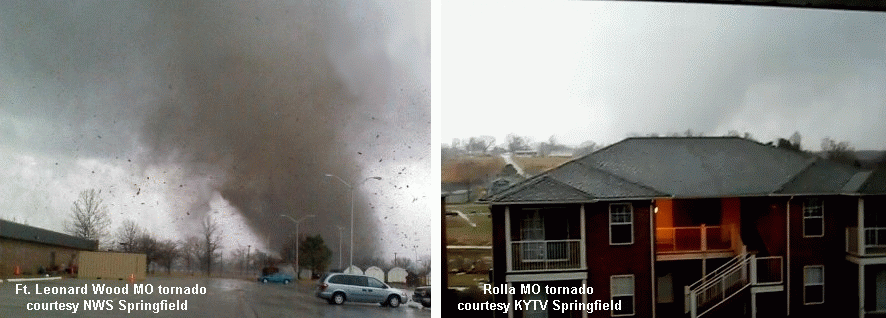
Killer tornadoes in Missouri are somewhat rare during the month of December, but do happen (5 such events since 1950 prior to 2010). Last Friday's tornado outbreak that left 4 dead in central MO (in addition to 3 dead in northwest AR) was also rare in that the Missouri tornadoes occurred at mid morning (see photos above at Ft. Leonard Wood and Rolla). Another interesting aspect of the outbreak was its evolution from a complex beginning with 2 supercells close to each other in eastern OK into a bow echo structure over eastern MO, persisting for over 6 hours through parts of OK/AR/MO/IL.

The 2nd and 3rd graphics above are regional radar reflectivity composites showing the broad evolution of this complex from 2 distinct long track supercells (circled in white) around 1200 UTC/6 a.m. through 1600 UTC/10 a.m., toward merging into a bow echo type structure after that, with several embedded tornadoes in the St. Louis area around noon. Locations of some stronger tornadoes (EF2+) and deaths are indicated on these graphics. Some of the tornadoes in the latter stages of this complex may have been bow echo/QLCS tornadoes associated with mesovortices instead of deeper mesocyclones. At any rate, this is an interesting example of an event metamorphasis from quasi-discrete supercell mode to a more linear or bow echo mode with embedded tornadoes continuing during both modes.

The environment ahead of the large upper trough (not shown) generating the storms was a classic "small CAPE/large shear" setting so common with winter tornado events. The RUC sounding analysis for 1500 UTC (9 a.m.) at West Plains MO (UNO, see 4nd graphic above) during the hour before the Ft. Leonard Wood and Rolla tornadoes (both from northern supercell, 2 deaths) and Lecoma MO tornado (southern supercell, 2 deaths) showed this, with massive low-level shear and a very large clockwise-turning hodograph/wind profile in the lowest 1 km. Total CAPE of only 400-600 J/kg (620 J/kg sfc-based CAPE) in a close-to-saturated low level environment with little or no convective inhibition (CIN) was more than enough buoyancy to support strong supercell updrafts and deadly tornadoes in such a highly sheared environment.

Composite supercell tornado parameters sometimes have problems working well as indicators in such small CAPE environments. The last graphic above shows the significant tornado parameter (STP, effective shear version) along with radar and surface features around the time tornadoes were occurring in the St. Louis area; notice that not much "sig tor threat" was explicitly indicated over Missouri. Conditional sig tor probabilities (same graphic, same time, developed by Bill Togstad using one of my RUC sounding databases) suggested more tornado potential in the St. Louis area, probably because Bill's equation seems somewhat more "tuned" toward detecting smaller CAPE settings with potential for tornadoes, a nice characteristic, but also one that can sometimes increase false alarms in marginal situations.

At any rate, such a prolific, persistent, and mode-evolving complex (6 hrs+ life span, 7 total deaths) is a rather rare event in the Missouri area, particularly on New Years Eve Day! More survey information can be found at NWS Tulsa, NWS Springfield, and NWS St. Louis sites.

- Jon Davies 1/5/11