Wednesday, January 12, 2011

Reed Timmer to speak in Kansas City January 18


My wife Shawna is currently vice president of the Kansas City AMS/NWA Chapter. She asked me to announce that Reed Timmer from "Storm Chasers" will be our guest presenter at the January 18th chapter meeting! It will be held at Ameristar Casino, 3200 North Ameristar Drive in Kansas City MO. See the flier above.

Reed's talk is "TVN Storm Chasing and Extreme Tornado Research -- the Measurement of Vertical Tornado Winds from Inside the Funnel." He will also have his book "Into the Storm" available for purchase.

This is open to the public. The price is $24.00 per person for both dinner and talk. Make sure to RSVP by January 14 (Friday) 11:00 a.m. by e-mail to my wife Shawna at shawnadavies@gmail.com or to Jim Keeney at Jim.Keeney@noaa.gov.

Storm chasers and weather enthusiasts in the Missouri/Kansas/Nebraska/Iowa area, please pass the word!

Thanks!

- Jon Davies 1/12/11

Wednesday, January 5, 2011

Long-lived tornadic supercell complex kills 7 in AR/MO 12/31/10


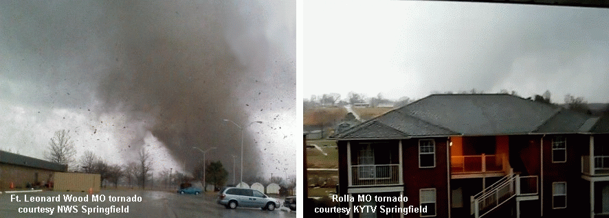
Killer tornadoes in Missouri are somewhat rare during the month of December, but do happen (5 such events since 1950 prior to 2010). Last Friday's tornado outbreak that left 4 dead in central MO (in addition to 3 dead in northwest AR) was also rare in that the Missouri tornadoes occurred at mid morning (see photos above at Ft. Leonard Wood and Rolla). Another interesting aspect of the outbreak was its evolution from a complex beginning with 2 supercells close to each other in eastern OK into a bow echo structure over eastern MO, persisting for over 6 hours through parts of OK/AR/MO/IL.

The 2nd and 3rd graphics above are regional radar reflectivity composites showing the broad evolution of this complex from 2 distinct long track supercells (circled in white) around 1200 UTC/6 a.m. through 1600 UTC/10 a.m., toward merging into a bow echo type structure after that, with several embedded tornadoes in the St. Louis area around noon. Locations of some stronger tornadoes (EF2+) and deaths are indicated on these graphics. Some of the tornadoes in the latter stages of this complex may have been bow echo/QLCS tornadoes associated with mesovortices instead of deeper mesocyclones. At any rate, this is an interesting example of an event metamorphasis from quasi-discrete supercell mode to a more linear or bow echo mode with embedded tornadoes continuing during both modes.

The environment ahead of the large upper trough (not shown) generating the storms was a classic "small CAPE/large shear" setting so common with winter tornado events. The RUC sounding analysis for 1500 UTC (9 a.m.) at West Plains MO (UNO, see 4nd graphic above) during the hour before the Ft. Leonard Wood and Rolla tornadoes (both from northern supercell, 2 deaths) and Lecoma MO tornado (southern supercell, 2 deaths) showed this, with massive low-level shear and a very large clockwise-turning hodograph/wind profile in the lowest 1 km. Total CAPE of only 400-600 J/kg (620 J/kg sfc-based CAPE) in a close-to-saturated low level environment with little or no convective inhibition (CIN) was more than enough buoyancy to support strong supercell updrafts and deadly tornadoes in such a highly sheared environment.

Composite supercell tornado parameters sometimes have problems working well as indicators in such small CAPE environments. The last graphic above shows the significant tornado parameter (STP, effective shear version) along with radar and surface features around the time tornadoes were occurring in the St. Louis area; notice that not much "sig tor threat" was explicitly indicated over Missouri. Conditional sig tor probabilities (same graphic, same time, developed by Bill Togstad using one of my RUC sounding databases) suggested more tornado potential in the St. Louis area, probably because Bill's equation seems somewhat more "tuned" toward detecting smaller CAPE settings with potential for tornadoes, a nice characteristic, but also one that can sometimes increase false alarms in marginal situations.

At any rate, such a prolific, persistent, and mode-evolving complex (6 hrs+ life span, 7 total deaths) is a rather rare event in the Missouri area, particularly on New Years Eve Day! More survey information can be found at NWS Tulsa, NWS Springfield, and NWS St. Louis sites.

- Jon Davies 1/5/11

Wednesday, December 15, 2010

Rare EF2 tornado in Oregon 12/14/10


Yesterday (Tuesday 12/14/10) saw an EF2 intensity tornado strike just southeast of Salem, Oregon shortly before noon PST (2000 UTC) at Aumsville (see photo above), with 2 injuries reported. It's been 17 years (1993) since a tornado that strong occurred in Oregon, and it was only the 4th tornado of F2/EF2 or stronger intensity to occur in the state since the early 1970's. Such events are so rare that they are typically unforecastable, as they usually occur in settings with small CAPE (<> 40 deg F) from western Washington into west central Oregon, and some spotty sun's heating on satellite. Although SPC mesoanalysis graphics showed total CAPE amounts not really registering (less than 250 J/kg, not shown), some low-level CAPE (SBCAPE below 3 km AGL) was indicated over the same area where dew points were maximized (see red areas in 4th graphic above at 1900 UTC). The small tornadic cell formed rapidly around 1910 UTC and began producing a five-mile track tornado around 1945 UTC (see radar inset on 4th graphic).

As is often the case in small CAPE settings, RUC soundings tended to under-estimate the environmental CAPE in this setting, showing surface temperatures around 45 deg F and surface dew points around 40 deg F. However, actual surface observations at Salem at 1900 UTC (not shown) before the tornadic cell formed were 47 F (temperature) and 42 F (dew point). When plugged into the RUC analysis sounding for Salem at 1900 UTC (last graphic above), these updated surface obs combined with cold air not far aloft (-10 deg C at 700 mb !) boosted total CAPE from around 100 J/kg to over 300 J/kg, with the "fattest" CAPE located in the 950-850 mb layer, very close to the ground. Even though total CAPE was unimpressive, this "packing" of CAPE down low in the sounding environment would likely help promote rapid vertical stretching in a local updraft, and given the accompanying sizable low-level and deep-layer wind shear, was able to support a tornadic storm as reported above. But picking out these subtle ingredients in a rapidly evolving environment is more than difficult, and everything apparently had to come together just right to generate a tornado in this case. Another similar setting might generate only storms with small hail. Adding to these problems, rotation in small cells (like this case) more than 25-35 miles from radar is usually not detectable for advance warning purposes.

Although it's not hard to go back and see contributing factors after a climatologically rare small CAPE event like this, detecting in real time these subtle ingredients that might make for a mesoscale "accident" in a location where tornadoes don't often occur is next to impossible.

- Jon Davies 12/15/10

Saturday, December 4, 2010

Data collecting inside tornadoes - Will it improve warning lead times?


The Discovery television show "Storm Chasers" concluded another exciting season this past week. A repeating theme on the show is getting armored vehicles or probes into tornadoes (which makes for exciting storm chase footage) on the premise that this will help improve tornado warning lead times and save lives. But, in reality, that's really doubtful. Chuck Doswell's blog here discusses this issue very well. Measurements inside tornadoes may be useful toward understanding dynamics inside ongoing tornadoes (a valid goal), but will tell us next to nothing about which environments and storms will produce potentially deadly tornadoes. Chuck also points out that warnings for tornadoes most likely to cause deaths are already pretty good. Looking at four tornado days featured this season on "Storm Chasers" that each generated at least one violent EF4 tornado helps drive this point home rather well.

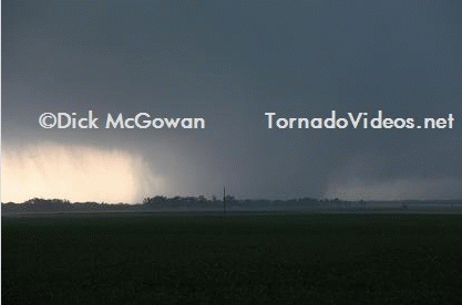
4/24/10 Yazoo City MS EF4 tornado (see photo by Dick McGowan above) - This tornado caused several deaths and was on the ground for 100+ miles in a setting that was well-recognized by NWS meteorologists as having high potential for tornadoes well in advance (for example, see experimental conditional sig tor probabiliities on 1st map graphic above). The specific warning for Yazoo City was issued approximately 30 minutes before the tornado hit town, and warnings for the same tornadic storm farther west had been ongoing for an hour. Can we really improve on those good lead times?

5/10/10 Tornadoes in central OK, including EF4 tornadoes just southeast of Oklahoma City - Again, the potential for this day was outlooked well in advance, with the coming together of environment ingredients quite evident (see 2nd graphic above). Tornado warnings in central Oklahoma were generally issued 30 minutes in advance of damage and deaths.

5/22/10 EF4 tornado near Bowdle in north-central ND - This setting was also quite evident in advance (see 3rd map graphic above), where a large tornado hit mainly in open country. A tornado warning for Bowdle was issued nearly 30 minutes in advance of the tornadic storm passing just northwest of town, and tornado warnings farther west had been ongoing for about an hour.

6/17/10 Tornadoes in MN, including the EF4 Wadena MN tornado - Another setting where tornado environment ingredients were very evident (see last graphic above) in advance, and most warnings were issued 30 minutes before sizable towns were struck.

Here are some representative values of individual bulk environmental ingredients associated with the above cases:

4//24/10 MLCAPE 1950 J/kg 0-1k SRH 670 m2/s2 0-6km shear 70 kts
5/10/10 MLCAPE 3340 J/kg 0-1k SRH 610 m2/s2 0-6km shear 62 kts
5/22/10 MLCAPE 3930 J/kg 0-1k SRH 345 m2/s2 0-6km shear 52 kts
6/17/10 MLCAPE 2525 J/kg 0-1k SRH 270 m2/s2 0-6km shear 54 kts

Any competent NWS meteorologist on days with environment ingredients like those above would be primed and ready to issue warnings immediately at the first indication on radar or credible information from spotters. The next level of improvement regarding saving lives will likely involve sociology to find ways to get people to hear and pay attention to those warnings already being issued.

The Discovery show is about 95% thrills and entertainment, and maybe 5% real science. But it makes interesting watching for legions of viewers, and I do commend the show producers this season for balancing the adrenaline quotient with some sober reality by showing the aftermath of tornadoes, including damage and injuries.

- Jon Davies 12/5/10

Tuesday, November 9, 2010

November funnels near Bakersfield CA


My friend composer/conductor William Stromberg (who also storm chases with his wife Anna Bonn) sent me the cool photos above taken by his brother Robert Stromberg (production designer and Oscar winner earlier this year for the film Avatar) yesterday morning while driving on Interstate 5 near Bakersfield, California (about 90 miles north-northwest of Los Angeles). These came out of some very low-topped convective showers associated with a potent upper storm system but limited instability, so I thought the setting was worth a look.

The 500mb forecast during the day on 11/8/10 (see 3rd image above) showed a strong upper trough (heavy black dashed line) moving across California and Nevada. Although a surface cool front (not shown) associated with this trough had already moved through the area, there was just enough moisture (surface dew points in the upper 40s F) and cold air aloft for a little sun-driven surface heating to pop some small showers (see satellite image above) in the Bakersfield vicinity, aided by forcing from the upper system.

A RUC model analysis sounding estimate for Bakersfield (BFL, see last image above) at around 16 UTC (8 am PST, near the time of the funnels), indicated a small pocket of CAPE/instability (possibly under-estimated by the RUC model) at around 3000 ft above ground, which is very near the surface. Apparently, enhanced stretching with the CAPE pocket so close to the ground, a steep lapse rate below cloud base, and the strength of the upper system combined to generate these "cold air" funnels within the updraft columns of 1 or 2 of the low-topped showers. As you can see, you don't always need alot of instability to get interesting things to happen with some fall and winter systems moving across southern and central California.

I didn't see any funnel or tornado reports online with the National Weather Service, so it may be that Robert was the only one to photograph these funnels. Many thanks to Robert and William for sharing these photos of an event that would otherwise have probably gone undocumented!

- Jon Davies 11/8/10

Tuesday, October 26, 2010

Late October EF2 tornado at Rice TX


There's been no shortage of interesting tornado events the past couple months, with a tropical system producing tornadoes in the Dallas TX area and a bow echo type tornado in the Queens/Brooklyn area of New York City in September, and damaging tornadoes in the high country of central Arizona in early October. I've been busy, so no case study posts on those events. Last Sunday saw a photogenic October EF2 tornado at Rice TX, southeast of Dallas and just north of Corsicana TX (see storm chaser Bridget Geaughan's photo above). Video shown on CNN from a range of about 100 yds from the tornado was quite impressive. Although there's nothing terribly unusual about an October tornado in Texas, I thought I'd at least post some brief material about the setting to help make up for lack of posts in recent weeks.

Probably the most interesting aspect of Sunday's afternoon setting is how quickly the low-level shear increased during the afternoon in response to the strong mid-level trough (see 2nd image above at 500 mb) moving west to east across Texas that helped fire up the storms ahead of a pre-frontal surface trough and wind shift (see surface map, 3rd graphic above). The SPC mesoanalysis showed 0-1 km storm-relative helicity (SRH, a measure of low-level wind shear, see 4th graphic above) at 2100 UTC / 4 pm CDT to be in the 100-150 m2/s2 range in the Rice TX area, values somewhat marginal for support of supercell tornadoes. However, by 2300 UTC / 6 pm CDT, about the time of the tornado, SRH values had doubled (> 250 m2/s2, same graphic) in response to the approaching mid-level trough, increasing the combination of SRH and MLCAPE (around 3000 J/kg) that could help generate low-level mesocyclones with stronger supercells (energy-helicity index near 3.0 and above by 2300 UTC, same graphic).

The RUC analysis profile at Corsicana TX, a few miles to the south of Rice at 2300 UTC during the tornado (see last graphic above), suggested strong combinations of parameters for supporting supercell tornadoes, even with a surface wind slightly west of due south. So a strong tornado occurring with a discrete supercell in this environment was not a surprise; SPC had a tornado watch issued well in advance, and a tornado warning was issued by NWS Ft. Worth based on radar roughly 15 minutes prior to the tornado.

- Jon Davies 10/26/10

Sunday, August 22, 2010

Wind damage (and mesovortex) near my home 8/20/10


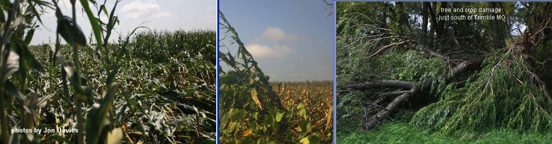
On Friday 8/20/10 while working at home (north of Kansas City), an intense squall line came through and caused an west to east swath of wind damage about two miles south of where I lived. The photos above show sections of corn crops flattened and some tree damage in that swath, damage I wasn't aware of until the next day when my wife Shawna noticed it while driving to Kansas City. There's really nothing unusual about this, except it seems the swath was associated with a forward "notch" in the line on radar, suggestive of a surface circulation with strong winds about 1-2 miles across called a mesovortex. The Kansas City NWS office at Pleasant Hill MO issued a tornado warning (based on this feature) a few minutes after it passed to the south of my house, and wind reports of 70-80 mph winds were verified in Holt MO, about 15 miles to my east. It's not too often a feature like this comes close to your home, so I thought I'd post a little documentation here.

NWS issued severe thunderstorm warnings for Clinton/Platte/Clay counties of MO well before the squall line passed my house. My photos above show views to the south and west as the line approached my home, with a bowing dark cloud shelf to my south and a ragged chaotic cloud base to my west just north of the "notch" on radar (I wasn't aware of the radar feature or damage until later). The forward flank "notch" can be seen on the radar base reflectivity images above (arrows), as well as the low-level base velocity image (circle). It was difficult to pick out a rotational "couplet" with this feature on storm-relative radar velocity images from the Pleasant Hill NWS radar (not shown). However, according to Evan Bookbinder at the NWS office, the closer and more favorably located Terminal Doppler Radar near MCI (KC International Airport, not shown) indicated a pronounced couplet with 80-90 mph winds toward the east on its south side as the feature approached Holt MO, prompting the tornado warning around 1905 UTC. The wind damage south of my home (a swath of 70-80 mph winds) clearly lined up with this radar feature before the tornado warning as it tracked eastward.

A surface map is also shown above, showing the squall line location after 1800 UTC, and surface temps in the 90s F ahead of the line with dew points in the mid-upper 70s F. The early afternoon environment over northwest Missouri (not shown) was quite unstable, with CAPE values near 4000 J/kg, around 30-35 knots of deep layer shear (0-6 km AGL), but little low-level shear (storm-relative helicity less than 80-90 m2/s2). So, the CAPE/shear setting was supportive of strong organized storms (possible supercells) with potential for wind damage, but suggested little support for much in the way of tornadoes. Forward flank squall line circulations in such settings can certainly produce notable wind damage, and even occasional weak/brief tornadoes of non-supercell origin.

- Jon Davies 8/22/10