A week ago, May 5 - May 7, 2019 saw several supercells and tornadoes over the central Plains (for example, see images above by Tony Laubach on May 6 after dark in central Kansas ). Thankfully, there were no serious injuries from any of the storms. But boundaries on these days certainly had some influence on whether particular storms did or did not produce tornadoes.
This post will look at boundary details that likely contributed to certain storms being tornadic or non-tornadic on these three days, using surface, satellite, and radar data.
First, on Sunday May 5, an outflow boundary was leftover from morning convective showers over central and southern Kansas, seen on this noontime visible satellite image:
By mid-afternoon, this boundary was still visible over central Kansas, along with a dryline wind shift boundary over southwest Kansas that was marked by newly-developing cumulus (also see the 4:00 pm CDT surface map below):
By 5:00 to 6:00 pm CDT, storms had developed from Kansas to west Texas:
It's notable that the storm/storm cluster in central Kansas near the old outflow boundary on May 5 produced tornadoes off and on for at least a couple hours as the cluster moved southeast near this boundary, including this EF1 tornado northwest of Hutchinson, Kansas:
The SPC mesoanalysis depiction of the significant tornado parameter (STP) at 5:00 pm CDT suggested that factors supporting supercell tornadoes (such as wind shear and CAPE) were maximized somewhat in central Kansas, probably due in part to this boundary:
It's interesting that the morning HRRR model forecasts (not shown) did not show any storms developing along this boundary. The tornadic storms on May 5 in central Kansas near Great Bend and Hutchinson probably would not have occurred without the remnants of the morning outflow boundary enhancing convergence and local wind shear.
A landspout also occurred on May 5 northwest of Dodge City between 5:00 and 6:00 pm CDT, as storms developed along the sharp wind shift boundary in southwest Kansas seen on the satellite photos earlier, where surface heating and CAPE intensified along the vorticity-rich boundary.
A large dusty tornado (EF2) also occurred with a supercell in west Texas south of Lubbock (image below), within the warm sector and not associated directly with a boundary. This was the strongest and longest-lived tornado of the day, and formed ahead of a dryline bulge within an environment of enhanced STP values in that area (see earlier STP graphic).
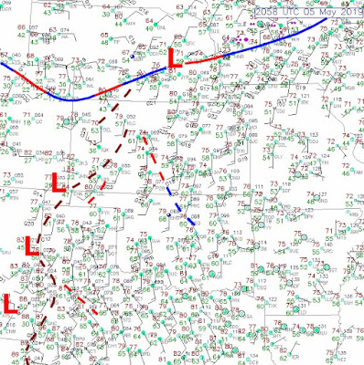
The next day (Monday, May 6), the 7:00 pm CDT surface map showed a slow-moving east-west front over central Kansas that initiated storms during the late afternoon and evening:
Between 6:30 and 7:00 pm CDT on May 6, storms on radar were ongoing in central Kansas, including a cell that was tornado-warned near McPherson (MPR, south of Salina/SLN). Note the blue "fine line" on the radar-image below, located just _south_ of McPherson and indicated by the small white arrows:
This strongly suggests that the tornado-warned storm was undercut by cold air north of the front, which is probably why the storm did not generate a tornado, although it did produce large hail (2"+). A photo of the McPherson storm also visually suggests it was occurring atop cold surface air, with lines of scud clouds visible near the ground and a laminar shelf forming:
Another tornado-warned storm was located farther west, northeast of Dodge City (DDC), also just north of the surface front (dashed line below) with cold air likely undercutting it, as suggested by the frontal "fine line" position (not shown) from the Dodge City radar:
As the evening went on, the boundary slid southward through Dodge City (still visible as a "fine line"), but then slowed down as storms consolidated into a significant supercell just northeast of Kinsley, Kansas after 9:00 pm CDT:The SPC mesoanalysis depiction of STP at 9:00 pm CDT showed an environment supportive of tornadoes feeding into this supercell from south of the boundary:
It's also interesting that, farther west, a tornado occurred around 9:20 pm CDT at the location where the aforementioned boundary hooked into the approaching squall line west of Dodge City (see the 9:16 pm CDT radar image up above). This boundary intersection would be a favored location for a tornado from an embedded circulation at the intersection point.
So, it seems that the boundary positioning on May 6, depending on whether a particular storm had access to warm and unstable surface air or was located over the top of cold post-frontal surface air, had much to do with tornado potential.
I don't have much room here to go into Tuesday, May 7 in the Texas panhandle. But it is worth noting that a stationary front oriented southwest to northeast appeared to have much to do with supercells' ability to produce or not produce tornadoes that Tuesday afternoon. Storms immediately north of Amarillo at mid-afternoon appeared unable to produce tornadoes when they moved north of a fine line (not shown) marking the frontal position and colder surface air. However, some storms located more to the northeast of Amarillo were able to access warm and unstable surface air due to their location just south and east of this same boundary:
SPC's own Roger Edwards was chasing near Amarillo that afternoon, and noted on his Twitter post to #txwx the cold air coming out of the storm he was chasing just north of the boundary, indicative of the coldness of the surface air associated with the boundary:
Here's the SPC depiction of STP at mid to late afternoon, suggesting a supportive environment for supercell tornadoes over much of the Texas panhandle, but not doing much to indicate where the surface frontal boundary and cold surface air were truly located:
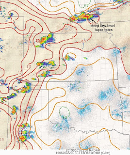
This is why it is so important to keep track as much as possible where relevant surface boundaries are located when considering which storms are more likely to produce tornadoes.This high-based tornadic storm formed just ahead of a slow-moving east-west front where SPC mesoanalysis graphics indicated steep low-level lapse rates (below). This suggests the tornado might have been some kind of a "hybrid event" where a front flank mesocyclone and the storm's gust front got together in some way to produce the tornado.
In summary, May 5, 6, and 7 had some very interesting settings for tornadoes in the Plains, and provided some excellent examples of how boundaries can sometimes help and other times hurt tornado production.
- Jon Davies 5/12/19


No comments:
Post a Comment