
What I do want to focus on is a tornado (rated EF2) northwest of Aberdeen in South Dakota near the town of Wetonka, around the time that the tornado pictured above was happening in Canada. The South Dakota tornado was the first significant tornado in the U.S. since June 10th, a surprising 25-day streak during a late spring / early summer period that has seen below normal tornado activity in 2020.
**** UPDATE Note: NWS Cheyenne WY was slow in rating an EF2 tornado northwest of Hemingford, Nebraska on July 2, 2020. Now with that new information, I make the correction that the Nebraska tornado on 7/2/20 was the first significant tornado in the U.S. since June 10. ****
The Wetonka, South Dakota tornado came from this supercell, shown around an hour before the tornado:
The Wetonka, South Dakota tornado came from this supercell, shown around an hour before the tornado:

I wanted to document that the evolution of the supercell and its associated outflow boundary before the tornado was something you don't see that often.
Below is a 3-panel base reflectivity sequence during the 30 minutes prior to the tornado. Notice the outflow boundary (fine blue line) ahead of it:

Again, this was something of an unusual case in that the storm was able to pull its own outflow boundary (initially surging southeast) back in underneath its updraft to access the unstable warm sector inflow air necessary to support the formation of a tornado.
This suggests that meteorologists and storm chasers should remain alert to the possibility of slowing outflow that might allow a supercell to catch up to its leading edge and reconfigure the storm's outflow boundary underneath it.

- Jon Davies 7/6/20
Below is a 3-panel base reflectivity sequence during the 30 minutes prior to the tornado. Notice the outflow boundary (fine blue line) ahead of it:

This outflow surged out southeast in front of the storm in the hour before the tornado, suggesting that the supercell was "outflow-dominant" (rain-cooled air moving outward from the storm), usually signaling to meteorologists and storm spotters that tornado development is unlikely. In other words, the cool outflow air would undercut the storm updraft beneath which a tornado might form.
However, in this case, the outflow _slowed_ and the rotating supercell storm caught up to it, pulling and wrapping the outflow boundary back in under the storm and updraft. At the white arrow in the radar images above, see the fine blue line slow and then curl back northwest into the supercell as a 'hook-shaped' echo forms (see last panel above at 7:27 pm CDT), allowing the supercell updraft to access warm moist inflow air at the surface. This was likely an important factor in the storm's ability to produce a tornado.
The zoomed-in radar image below is during the tornado moving southeastward near Wetonka. The circle indicates the supercell mesocyclone where the tornado was located, and I've also indicated with a dashed white line the boundary and inflow wrapping way back into the mesocyclone from the east during the tornado.

As seen in the earlier radar sequence, outflow initially surging out ahead of the storm was probably a reason why the storm was not tornado-warned, only severe-warned. Typically, once a supercell becomes outflow-dominant, it remains that way, unlike this case. It is somewhat unusual to see an outflow boundary out ahead of a storm get pulled back in underneath it, suggesting that the supercell mesocyclone on July 4 was rather strong, while at the same time the initial outflow air in advance of it was modifying and weakening.
From the radar images above, it appears the supercell mesocyclone was largely wrapped in rain, a probable reason why there are no photos of the tornado from local residents near Wetonka.
The storm environment, while not remarkable, was certainly supportive of supercell tornadoes. The SPC mesoanlysis graphic below shows that the effective-layer significant tornado parameter was maximized over north-central South Dakota in the vicinity of the supercell:

Also, here is a RAP model sounding (below) from a point just south-southwest of the supercell at 7:00 pm CDT, about a half hour before the tornado:

Low-level wind shear was just enough (storm-relative helicity or SRH near 100 m2/s2) with a looping low-level wind profile, and over 30 knots of deep-layer wind shear was also present. Total mixed-layer CAPE was large (> 3500 J/kg), and low-level mlCAPE was also significant (0-3 km mlCAPE around 140 J/kg). This latter ingredient, along with the available low-level wind shear, would likely facilitate low-level stretching and 'spin' to help generate a tornado, _if_ a rotating storm could access the unstable inflow air ahead of it's own outflow.
Again, this was something of an unusual case in that the storm was able to pull its own outflow boundary (initially surging southeast) back in underneath its updraft to access the unstable warm sector inflow air necessary to support the formation of a tornado.
This suggests that meteorologists and storm chasers should remain alert to the possibility of slowing outflow that might allow a supercell to catch up to its leading edge and reconfigure the storm's outflow boundary underneath it.
Now, let's go back to the Saskatchewan supercell I mentioned at the top. It moved east-southeast along a wind shift boundary marked by the dashed red-blue line in the satellite image below at 0016 UTC:

This supercell produced three tornadoes as it moved along this boundary, but thankfully all were in open country.
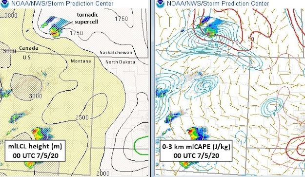
What's interesting about this supercell is that it appeared to produce tornadoes in an environment with rather high lifting condensation level (LCL) heights (1750-2000 m above ground), as seen below in the 00 UTC 7/5/20 SPC mesoanalysis:

It also appeared to occur in a setting with little low-level wind shear (SRH < 50 m2/s2, not shown). These factors are generally negatives for supercell tornado potential.
However, the tornadic Canadian cell did occur in an area of enhanced low-level CAPE (see 2nd SPC panel above), which could enhance low-level stretching, as well as enhanced surface vortcity (light blue lines in 2nd panel, a source for 'spin') near the aforementioned boundary. Low-level lapse rates were also steep along this boundary (near 9.0 deg C, not shown), which could help with low-level stretching.
These ingredients together suggest that there may have been some non-supercell processes contributing to this Canadian tornado event, in addition to supercell processes (see my prior blog post here). But that's speculative, because the SPC data is at the edge of the SPC mesoanalysis and RAP model domain, which could affect the accuracy of soundings and parameters. Still, this Canadian case deserves some further study.
So, even in a slow tornado year, there are definitely interesting cases to examine!
- Jon Davies 7/6/20
No comments:
Post a Comment