Saturday, October 31, 2020

Robert (Bob) Johns - dynamic SPC forecaster and researcher - passes away at 78.


This blog post is about Bob Johns, long-time Storm Prediction Center severe weather forecaster/researcher, who passed away at age 78 this past week after a long illness.

He was such an incredible influence in my life.  

In the late 1980's, I had worked in television and consulting firms for several years without finding much stability or direction in my weather career.  I had moved back to my home area to help take care of my ailing mom and assist my dad with his expanding home medical business in rural Kansas.  I thought my career in weather was over. 

However, I still had an interest in severe weather.

In 1989, I drove to Kansas City and the National Severe Storms Forecast Center (NSSFC, now the Storm Prediction Center) to find meteorological maps for some 1988 tornado events (there was no internet with online weather information yet).  As I was shuffling through paper in their map archive room, Bob Johns walked by and introduced himself.  We started talking, and that conversation changed the course of my life.

Bob sensed the untapped passion I had for tornado forecasting and severe weather research, something that hadn't been encouraged by anyone I had worked with so far.  To my surprise, he enlisted me in a research project he wanted to do using weather balloon soundings archived from the 1980's to examine environments of significant tornadoes using newer measures of wind shear.  Something like that wasn't easy to do back then without the sophisticated computer software for analyzing soundings that we have now.  

The result was several research papers we authored together in the early 1990's that laid some groundwork for using wind shear and instability combinations in tornado forecasting. This included the Energy-Helicity Index (along with SPC forecaster and programming wiz John Hart) as a composite parameter in tornado forecasting. 

I was thrilled that he asked me to work with him on this project.  In his quiet but enthusiastic way, one of Bob's gifts was recognizing people's abilities and inspiring them to use and develop them.   I am very blessed that he took an interest in me, and his mentorship was essential in nudging me in a different direction at a key time in my life.

Here'a photo of NSSFC staff back in 1977: along with Bob Johns, it includes forecasters Steve Weiss, Larry Wilson, and Jack Hales.  Bob introduced me to these NSSFC 'stalwarts', who were all very kind and encouraging to me.  I also met severe weather icons Chuck Doswell, Don Burgess, Robert Davies-Jones, and others through him, which was quite amazing yet humbling for someone so new to weather research and writing. 

Bob started at NSSFC in Kansas City in 1971, learned much about severe weather forecasting and issuing watches from forecaster Larry Wilson, and became a lead forecaster at NSSFC by 1979.  He worked in that capacity until 1994 when he became Scientific Operations Officer at the time SPC moved to Norman, Oklahoma.  He retired in 2001, after which he worked part-time.  It is noteworthy that Bob introduced the enhanced "Particularly Dangerous Situation" (PDS) wording to tornado watches during the 2 April 1982 tornado outbreak in Texas, Arkansas, and Oklahoma.

Chicago weather legend Tom Skilling wrote the following on Facebook after Bob John's passing this week:

"Anyone who has worked in the meteorological profession has read and studied Johns' remarkable work on severe weather--work produced over an amazing decades-long career...

I first met Bob at one of our Fermilab Tornado and Severe Weather seminars back in the 1990s... For someone who had so profoundly impacted the meteorological profession over his decades long career, it was such a joy to discover a soft-spoken man with a warm smile. Bob was so kind and so easy to approach... He had a passion toward meteorology and, in particular, severe weather and the manner in which nature put it together.  He spent his professional life cataloging what he had learned and worked tirelessly passing this information on to his colleagues and all interested in the subject."

I couldn't describe Bob better myself.  As Tom also mentioned in his FB post:

"His work on the prediction of "derechoes", the fast moving and destructive squall lines like the one which raced across our area at highway speed this past August, has been described as the "bible" on the subject for forecasters. His forecast techniques are still in use today. Johns published his study on the phenomenon with his National Weather Service colleague Bill Hirt in 1987."

Here's that paper:  Johns, R. H., and W. D. Hirt, 1987: Derechos: widespread convectively induced windstorms. Wea. Forecasting, 2, 32-49.

Bob's work on derechos (see my blog post on last August's derecho) helped make meteorologists and the public more aware of these large, destructive, and potentially deadly windstorms that can blast across several states.  His research has saved lives as a result.

Here's references for a little more of Bob's work:

As the last paper above reflects, Bob spent years studying and reconstructing the damage path of the famous 1925 Tri-State tornado in Missouri, Illnois, and Indiana.  It was a serious and fascinating subject for him.  That classic 2013 paper Bob wrote with Chuck Doswell, Don Burgess, and John Hart serves as the authoritative documentation and reference for that remarkable tornado.


Bob even wrote a book on the Tri-State Tornado, which you can buy on Amazon.

A more comprehensive list of Bob's published papers can be downloaded here:   http://www.ejssm.org/ojs/index.php/ejssm/article/downloadSuppFile/29/79

And for those who'd like more background on Bob John's growing up in Indiana and the development of his passion for severe weather, here's John M. Lewis' article about him in 2007:  https://ejssm.org/ojs/index.php/ejssm/article/view/29/32

Back in 2001, I was honored to be part of an evening seminar and review of the 1991 Andover, Kansas tornado where Bob talked about his handling of the event as a forecaster at NSSFC/SPC:

He taught me so much about research, staying disciplined, being practical, and staying clear in my focus and writing.  Bob helped give me confidence that I was missing in my young life, and he also taught me about being a decent human being,  I owe him a great deal.  

A final thought... Bob Johns was a wonderful reminder that we should treat those newer people finding their way in our chosen profession with respect and a helpful spirit.  He exemplified the importance of 'paying it forward' when we've had the good fortune to do what we love.

Rest in Peace, my friend.  You will not be forgotten.


- Jon Davies  11/30/20


Tuesday, September 1, 2020

Landspouts and the meteorological ingredients that can produce them

I've had some requests to update some material about landspout tornadoes that used to be on an old web site of mine, which is the reason for this post. 

A landspout tornado is a type of non-supercell tornado that can occur with a thunderstorm that doesn't have a rotating updraft detectible on radar (a mesocyclone).  Because of this, warnings can't be issued for landspout tornadoes based on radar - they have to be reported by spotters and storm chasers, and there is no warning lead time.  Thankfully, most landspout tornadoes are relatively weak, but on occasion they can become strong in the right setting.

How do landspout tornadoes form?

First, a sharp wind shift boundary must be present.  That's what provides the vorticity (or 'spin') needed for the tornado, when the low-level wind shear that helps to generate supercell tornadoes is absent:

Second, instability (or CAPE - convective available potential energy) must be present along the boundary for a thunderstorm updraft to develop.  In particular, CAPE in the lowest 3 km above ground helps because it can facilitate low-level stretching in updrafts along the boundary due to the instability being located closer to the ground.  

Third, steep low-level lapse rates (a rapid drop off in temperature in the lowest few kilometers above ground due to strong daytime surface heating) can also help accelerate low-level air upward in updrafts, increasing low-level stretching.

Here's one example of these ingredients coming together in a setting that might generate and support landspout tornadoes, using SPC mesoanalysis page graphics:  

If a thunderstorm updraft forms on a sharp boundary in such an environment with everything coming together just right (for example, the storm updraft must develop directly over the boundary and align properly with a small 'wiggle' or pocket of 'spin' on the boundary), the thunderstorm may then generate a landspout tornado through upward stretching of that 'spin':


Here's an example of a setting for landspout tornadoes that occurred on May 25, 2018 in both southern Minnesota (MN) and eastern Nebraska (NE).  The surface map at early afternoon on 5/25/18 showed a relatively stationary wind shift boundary (thick brown dashed line) stretching from a low in southern MN into east-central NE:

SPC mesoanalysis graphics at early afternoon on 5/25/18 showed plentiful low-level instability (0-3 km CAPE, in red, 1st panel below) over southern MN near the surface low where a storm was developing on the boundary (light blue lines also show surface vorticity or 'spin' along this boundary).  The 2nd panel below showed low-level lapse rates (0-3 km) to be steep over a large area, including all along the boundary, with lapse rates > 8.0 deg C shaded in orange:

Below is the developing storm on visible satellite (yellow arrow) at about 2 pm CDT.  Less than an hour later, a landspout tornado developed on the southwest edge of this new storm (photos also below):

From the 5/25/18 surface and SPC graphics up above, notice that all of the ingredients listed earlier for supporting landspout tornadoes (boundary, instability, steep low-level lapse rates) were present in this case, increasing the possibility of a landspout tornado _if_ the storm aligned properly with the boundary and the 'spin' along it.

Later in the afternoon, other storms developed southwestward on the wind shift boundary over Iowa and Nebraska.  After 5 pm CDT, a small high-based storm on the boundary over northeast/east-central NE (yellow arrow in satellite photo below) apparently "phased' with the boundary enough to produce yet another landspout tornado (see photos below):

As can be seen from the satellite photo, there were _many_ storms that developed along the boundary by late afternoon, but only _one_ of the Nebraska storms produced a tornado.  This certainly highlights that landspout tornadoes are not really forecast-able in advance.  A meteorologist can only note that ingredients possibly supportive of landspout tornadoes (the boundary, instability, low-level lapse rates) appear to be coming together in an area, so that reports of such tornadoes are not a surprise and can be warned immediately when spotted. 

Here are a few landspout tornado cases I've posted about on my blog:

    June 21, 2020 landspout tornado in northwest Kansas

    April 17, 2019 landspout tornadoes in Oklahoma, Kansas, and Texas

    May 19, 2012 non-supercell tornado outbreak in southern Kansas

And, for more technical reference, here are some papers that discuss landspout tornadoes:

    Non-supercell tornadoes (Wakimoto and Wilson 1989)

    Tornadoes in non-mesocyclone environments with pre-existing vertical vorticity along convergence boundaries (Caruso and Davies 2005)

    Tornadoes in environments with small helicity and/or high LCL heights (Davies 2006) 

It is also important to recognize that there are some cases where both non-supercell and supercell processes appear to be at work, particularly when winds aloft are strong enough to support and organize storms into supercells while ingredients related to landspout tornadoes are also present.  This is particularly true in the High Plains of the U.S., and such "hybrid" events are difficult to categorize.  Here are a couple examples:

    June 29, 2019 long-lived tornado in southwest South Dakota

    June 6, 2018 large and long-lived tornado near Laramie, Wyoming

Hopefully, this short discussion will help those interested in understanding some of the important factors and ingredients that contribute to landspout tornadoes.

- Jon Davies 9/1/20


Thursday, August 13, 2020

The August 10, 2020 Midwest Derecho - how did it develop?


Winds from the derecho on Monday, August 10 (pronounced 'day-ray-cho', a widespread convective system with high winds over a large area that can affect several states) killed two people, one in Iowa and one in Indiana, while leaving over a million people without electricity.  The images above show the derecho moving into Chicago at mid-afternoon, the derecho's shelf cloud approaching Sioux City, Iowa on Monday morning, and major damage in Marshalltown, Iowa at mid to late morning.   

The derecho capped off a very active (for August) 7-day period of severe weather.  August 3-4 saw numerous tornadoes associated with the remnants of Hurricane Isaias from North Carolina (where 2 people died in a nighttime EF3 tornado) to Virginia, Maryland, Delaware, Pennsylvania, and New Jersey.  Then an EF2 tornado on the evening of August 7 killed two people in southwest Manitoba, Canada.

Monday's derecho started in the early morning hours over South Dakota, crossed Iowa during the morning, and hit Chicago and northern Indiana in the afternoon.  Here's an hour by hour composite radar image from NWS Chicago that shows the derecho's rapid progress:


And here's the associated storm reports showing the wide axis of damage across several states, including some embedded "bow echo" or QLCS-type EF0-EF1 tornadoes in the Chicago area:


How does a derecho like this form?  Large convective systems are pretty common across the Midwest in summertime.  So, what causes one of these systems to become a dangerous and deadly squall line or cluster of storms?  Answers have to do with the origin area of the derecho (south-central/southeast South Dakota in this case), as well as the synoptic setting out ahead of it.

Below is the surface map at 5:00 am CDT on 8/10/20, along with a radar inset focused on south-central South Dakota (SD).  I've indicated the genesis region of the derecho, where an area of thunderstorms had formed during the early a.m. hours within the thick black oval on the surface map, north of a frontal boundary over Nebraska:

A RAP model forecast sounding at Lake Andes, SD, just east of these thunderstorms, is shown below:

Notice that there was a significant layer of dry air in the lowest 3 km, indicated by the broad distance between the red temperature and blue dew point curves in lower levels.  This was _below_ a relatively moist layer beginning at roughly 3 km above ground where significant CAPE was present from a lifted parcel at that elevated level.  With little or no convective inhibition (CIN) at this level, elevated storms could initiate well north of the surface front over Nebraska (see 5:00 am surface map earlier), and rain into this dry layer below.

This would produce strong evaporative cooling, creating dense cool air accelerating downward and outward and generating strong surface winds beneath and ahead of the expanding elevated storms over southern SD.  Here's a diagram illustrating that process for many summertime derechos that initiate in the northern Plains of the U.S.:

This may look similar to diagrams of downbursts and microbursts, which are much more localized.  But what is different and important in Monday's case is that the evaporative cooling and downward air acceleration was taking place over a larger area with the _cluster_ of developing storms, rather than a single thunderstorm.  This then spread out into the broad squall line and convective system seen in the composite progressive radar image earlier.

I should emphasize that soundings like the one at Lake Andes up above, with a moist layer of sizable elevated CAPE above a significant layer of dry air (a type of  'overrunning' situation, north of the Nebraska frontal boundary seen on the earlier surface map) are not that common.  With a developing thunderstorm cluster, it's a little unusual to see such an elevated moist layer located that far above a depth of much drier air beneath.

Below is the 500 mb NAM model forecast for 4:00 am CDT in the mid-levels of the atmosphere on 8/10/20, showing a significant shortwave disturbance (thick dashed black line) moving across the northern Plains. This disturbance provided the upward forcing that helped fire up the elevated thunderstorms over southern SD that evolved into the derecho:


The inset on the graphic above is a forecast of mlCAPE valid at 7:00 am CDT, showing a long axis of instability extending eastward to Chicago, a corridor that would feed and maintain the convective complex and derecho as it evolved and moved eastward across several states during the morning and afternoon.

A similar situation accompanied a developing derecho that my wife Shawna and I experienced at Pierre SD in the early morning hours of 6/22/15, five years ago.  Below is the surface map with the genesis region of the derecho indicated around Pierre at 1:00 AM CDT on 6/22/15:


Here is the RAP model sounding at Pierre SD at about the same time:


Notice that the environment was similar to the 8/10/20 "genesis region" sounding shown earlier, with an elevated moist layer and sizable CAPE located _above_ a dry layer in the lowest 3 km.  As new storms formed west of Pierre around midnight, evaporative cooling of rain through this dry layer resulted in the generation of very strong winds (120+ mph measured at Hayes SD!) that caused widespread damage in Pierre (including our motel) and locations eastward on 8/22/15 as the storms morphed into a derecho event.

Many derechos that initiate over the northern Plains and move eastward through the Midwest (the most common area for derechos in the U.S.) probably have this type of atmospheric setting in their genesis region.  The drier air in the lowest 2-3 km below an elevated moist layer can result in rapidly-developing strong convective surface winds that spread eastward as a derecho along a west to east corridor of instability.  

An important factor is the presence of a stationary or quasi-stationary west-east front (check out the surface maps earlier) with this axis of unstable air along it, helping to provide a corridor along which the recently-intiated derecho can intensify, spread, and maintain itself moving eastward.  This was a key feature of Robert John's seminal work on derechos at SPC in the 1980's (see this paper).  Johns deserves much credit for making forecasters and meteorologists more aware of these dangerous convective systems.

Derechos are more complicated than this brief analysis would suggest.  But I've touched on a few factors that are important for many warm season derechos across the Midwest.

- Jon Davies 8/13/20 

Sunday, August 2, 2020

A 'surprise' tornado on July 29, 2020 north of Kansas City - another subtle, marginal summer tornado setting

I've had several people ask me what was going on with the unexpected but well-photographed tornado (above, EF0) last Wednesday 7/29 at early afternoon near Smithville, MO, north of Kansas City, only a few mile north of where I live.  I was quite surprised when I heard about the warning associated with it, and wondered myself how there could be a tornado on this particular day.

Although not something one could really anticipate, a careful look back at the setting revealed that it was not 'random' or 'from out of the blue'.

There was a well-defined boundary (dashed red-blue line below; a weak stationary front?) on the surface map at noon on 7/29/20 across the Kansas City metro area, delineating south winds to the south of the boundary from light easterly winds on the north side of it:
As many forecasters and researchers have pointed out in recent years, tornadoes like boundaries, often because favorable wind shear (a change in wind direction and speed as winds veer with height) that might help generate a 'spin up' can be present along and across such boundaries.  The black-circled 'S' on the map above shows that the location of the small supercell that later spawned the weak tornado was indeed very close to the boundary.

Here's satellite and zoomed-in radar reflectivity near the time of the tornado (1:45 pm CDT, or 1845 UTC), with a white circle showing the location of the supercell mesocyclone and rotation in the storm near Smithville:
It is also interesting that a broad, weak low was present at 700 mb (roughly 10,000 ft above sea level) nearby over southeast Nebraska at midday on the SPC mesoanalysis:
This weak low aloft and a short wave trough (heavy black dashed line) moving around it helped provide lift for generating thunderstorms over northeast Kansas and northwest Missouri.  In a way, this looked like a weak 'cold-core' tornado setting, and coupled with the east-west surface boundary, was another factor that may have helped set the stage for a tornado.

The storm environment, though subtle, also offered some ingredients that were marginally supportive of supercell tornadoes.  The first panel below from the SPC mesoanalysis at 1800 UTC (noon CDT) showed that low-level wind shear, though not large, was enhanced some just north of the east-west boundary (0-1 km storm-relative helicity / SRH > 50 m2/s2), as one might expect with easterly surface winds just north of Kansas City on the surface map earlier:


The 2nd panel above showed that instability in low-levels close to the ground was large (0-3 km mlCAPE > 150 J/kg) near the boundary across the Kansas City area.  Although subtle, combinations of both low-level shear and instability together were largest in that area (see black oval in 1st and 2nd panels above), just south of Smithville.

One last ingredient was deep-layer wind shear (surface to 6 km above ground, 3rd panel above) that was near the lower limit (around 25 kt) of what is considered supportive for supercell storms.  But on this day it was enough to do the trick.

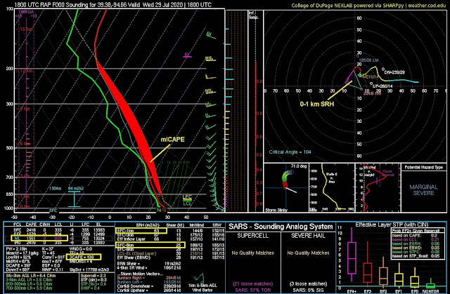
Here's a RAP model analysis sounding estimate of the environment near Smithville at midday along the east-west boundary:

Although not impressive, the instability (which I've manually shaded in red above) and vertical wind shear were apparently just enough to help generate and support a tornado as the supercell crossed the surface boundary moving north-northeast.  

In particular, the instability in lowest levels close to the ground probably helped with stretching of air in the small storm's updraft as it interacted with the local boundary.  The photo below shows a cloud ridge flowing into the storm with 'vapory-looking' scud close to the ground, a typical visual 'look' when large amounts of low-level CAPE are present not far above ground, and low-level stretching in updrafts may be enhanced.

This weak event wasn't of much importance (brief tornado, no damage), but is another illustration of how subtle ingredients can come together to produce a mesoscale 'accident'.  Given how marginal the setup was, an experienced nowcaster and meteorologist would not expect anything more than a weak tornado or two from such a setting.

- Jon Davies  8/2/20

Thursday, July 16, 2020

EF4 tornado in Minnesota on July 8, 2020 - a rather subtle environment for a violent tornado


After four EF4 tornadoes in April (3 in Mississippi, 1 in South Carolina), there were none in the U.S. in May and June.  But on July 8 in west-central Minnesota (MN), an EF4 tornado (images above) near Dalton, MN shortly after 5:00 pm CDT (2200 UTC) killed one person.  This was the first violent tornado in July in the U.S. since 2004!

The environment at first glance did not appear likely to generate a violent tornado, as low-level wind shear (storm-relative helicity, or SRH) wasn't notably large.  But there was a boundary in the area and large instability (CAPE), along with enough deep-layer wind shear to support tornadic supercells.  Here's a look at the setting...

SPC mesoanalysis graphics at 2200 UTC (5:00 pm CDT) showed large total CAPE (mlCAPE > 4000 J/kg, 1st panel below) near the soon-to-be tornadic storm that had developed during the previous hour in west-central MN:


Deep-layer shear (2nd panel above) was enough (30-40 kt) to help organize the isolated cell into a supercell.  Just as important, the cell developed near an east-west boundary (warm front /stationary front, also shown on the graphics above) that extended eastward from a surface low, a favorable setting for tornadoes when the surrounding environment offers additional support.

Also at 2200 UTC, low-level instability (0-3 km mlCAPE) was large over west-central MN (> 125 J/kg, 1st panel below), although 0-1 km SRH was nothing that would raise eyebrows much (0-1 km SRH 75-100 m2/s2, 2nd panel below):


But together, the combination of just enough low-level shear/SRH with strong low-level and total CAPE in the vicinity of the east-west boundary east of the surface low was more favorable for tornado potential than a look at wind shear parameters alone might suggest.

In fact, supercell and tornado development was rather fast and 'explosive', as seen in the two satellite images below:


In just less than an hour from initiation, the storm became a supercell and planted a strong/violent tornado on the ground.  That's quite fast compared to many supercells that take two hours or more to produce tornadoes.

A contributing factor to this rapid development may have been low-level lapse rates (below), not shown in the SPC graphics above:
The axis of red dots in the graphic above shows strong surface heating extending from the southwest into the supercell's environment near the boundary over west-central MN.  Such steep lapse rates (> 7.0 degrees C per km, a rapid change in temperature above ground) can enhance the stretching of low-level air entering storm updrafts, adding a 'kick' to an already unstable situation and helping to make the most of available low-level wind shear (SRH) as it tilts and stretches into an updraft.

Back around 2005, I came up with a parameter called 'enhanced stretching potential' (ESP) that combined low-level lapse rates with low-level CAPE to help locate areas that might have this extra 'kick'.  It was designed mainly for diagnosing short-term potential for landspout tornadoes along sharp boundaries (see this paper).  But on 7/8/20, ESP overlapped the area we discussed above that already had potential for tornadoes suggested by more typical supercell tornado parameters:
It may have added some 'gasoline' to the fire in this case, speeding up supercell and tornado development.  But that's only speculative.  I will mention that the prolific tornadic supercell in southern Saskatchewan (Canada) on July 4 that I touched on in my previous post had some of the same ingredients (SRH < 100 m2/s2, large CAPE and large ESP, as well as an east-west boundary; not shown).

As ESP was originally intended for highlighting short-term possibility for landspouts, it is worth noting on 7/8/20 that the ESP graphic above showed an ESP maximum over north-central Nebraska, where landspouts did occur later that evening along a boundary southwest of a storm near Thedford, Nebraska:

And other landspouts occurred on 7/8/20 along a boundary and boundary intersection over northeast Colorado where ESP was also large (not shown).

Finally, here's the large-scale NAM model 500 mb forecast for mid-afternoon on 7/8/20 showing the strong shortwave disturbance (red dashed line) in mid-levels moving through the northern plains that helped intiate the tornadic supercell in MN:

It is interesing that the early half of July 2020 has been more active for tornadoes in the central and northern Plains of the U.S. than in the last half of June.

- Jon Davies  7/16/20

Monday, July 6, 2020

Unusual EF2 tornado in South Dakota on July 4, 2020 is 1st strong tornado in U.S. since June 10


July 4th was a rather active day in the northern Plains of the U.S. and southern Canada.  In particular, a photogenic supercell with a sequence of tornadoes occurred in southern Saskatchewan on July 4 (see photo above).  This blog post isn't about that supercell, but I will discuss it briefly at the end here.

What I do want to focus on is a tornado (rated EF2) northwest of Aberdeen in South Dakota near the town of Wetonka, around the time that the tornado pictured above was happening in Canada.  The South Dakota tornado was the first significant tornado in the U.S. since June 10th, a surprising 25-day streak during a late spring / early summer period that has seen below normal tornado activity in 2020. 

**** UPDATE Note:  NWS Cheyenne WY was slow in rating an EF2 tornado northwest of Hemingford, Nebraska on July 2, 2020.  Now with that new information, I make the correction that the Nebraska tornado on 7/2/20 was the first significant tornado in the U.S. since June 10. ****

The Wetonka, South Dakota tornado came from this supercell, shown around an hour before the tornado:

I wanted to document that the evolution of the supercell and its associated outflow boundary before the tornado was something you don't see that often.

Below is a 3-panel base reflectivity sequence during the 30 minutes prior to the tornado.  Notice the outflow boundary (fine blue line) ahead of it:


This outflow surged out southeast in front of the storm in the hour before the tornado, suggesting that the supercell was "outflow-dominant" (rain-cooled air moving outward from the storm), usually signaling to meteorologists and storm spotters that tornado development is unlikely.  In other words, the cool outflow air would undercut the storm updraft beneath which a tornado might form.

However, in this case, the outflow _slowed_ and the rotating supercell storm caught up to it, pulling and wrapping the outflow boundary back in under the storm and updraft.  At the white arrow in the radar images above, see the fine blue line slow and then curl back northwest into the supercell as a 'hook-shaped' echo forms (see last panel above at 7:27 pm CDT), allowing the supercell updraft to access warm moist inflow air at the surface.  This was likely an important factor in the storm's ability to produce a tornado.

The zoomed-in radar image below is during the tornado moving southeastward near Wetonka.  The circle indicates the supercell mesocyclone where the tornado was located, and I've also indicated with a dashed white line the boundary and inflow wrapping way back into the mesocyclone from the east during the tornado.

As seen in the earlier radar sequence, outflow initially surging out ahead of the storm was probably a reason why the storm was not tornado-warned, only severe-warned.  Typically, once a supercell becomes outflow-dominant, it remains that way, unlike this case.   It is somewhat unusual to see an outflow boundary out ahead of a storm get pulled back in underneath it, suggesting that the supercell mesocyclone on July 4 was rather strong, while at the same time the initial outflow air in advance of it was modifying and weakening. 

From the radar images above, it appears the supercell mesocyclone was largely wrapped in rain, a probable reason why there are no photos of the tornado from local residents near Wetonka.

The storm environment, while not remarkable, was certainly supportive of supercell tornadoes.  The SPC mesoanlysis graphic below shows that the effective-layer significant tornado parameter was maximized over north-central South Dakota in the vicinity of the supercell:


Also, here is a RAP model sounding (below) from a point just south-southwest of the supercell at 7:00 pm CDT, about a half hour before the tornado:


Low-level wind shear was just enough (storm-relative helicity or SRH near 100 m2/s2) with a looping low-level wind profile, and over 30 knots of deep-layer wind shear was also present.  Total mixed-layer CAPE was large (> 3500 J/kg), and low-level mlCAPE was also significant (0-3 km mlCAPE around 140 J/kg).  This latter ingredient, along with the available low-level wind shear, would likely facilitate low-level stretching and 'spin' to help generate a tornado, _if_ a rotating storm could access the unstable inflow air ahead of it's own outflow.

Again, this was something of an unusual case in that the storm was able to pull its own outflow boundary (initially surging southeast) back in underneath its updraft to access the unstable warm sector inflow air necessary to support the formation of a tornado.

This suggests that meteorologists and storm chasers should remain alert to the possibility of slowing outflow that might allow a supercell to catch up to its leading edge and reconfigure the storm's outflow boundary underneath it. 

Now, let's go back to the Saskatchewan supercell I mentioned at the top.  It moved east-southeast along a wind shift boundary marked by the dashed red-blue line in the satellite image below at 0016 UTC:

This supercell produced three tornadoes as it moved along this boundary, but thankfully all were in open country.  

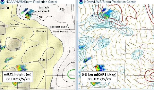
What's interesting about this supercell is that it appeared to produce tornadoes in an environment with rather high lifting condensation level (LCL) heights (1750-2000 m above ground), as seen below in the 00 UTC 7/5/20 SPC mesoanalysis:

It also appeared to occur in a setting with little low-level wind shear (SRH < 50 m2/s2, not shown). These factors are generally negatives for supercell tornado potential. 

However, the tornadic Canadian cell did occur in an area of enhanced low-level CAPE (see 2nd SPC panel above), which could enhance low-level stretching, as well as enhanced surface vortcity (light blue lines in 2nd panel, a source for 'spin') near the aforementioned boundary.  Low-level lapse rates were also steep along this boundary (near 9.0 deg C, not shown), which could help with low-level stretching.  

These ingredients together suggest that there may have been some non-supercell processes contributing to this Canadian tornado event, in addition to supercell processes (see my prior blog post here).  But that's speculative, because the SPC data is at the edge of the SPC mesoanalysis and RAP model domain, which could affect the accuracy of soundings and parameters.  Still, this Canadian case deserves some further study.
  
So, even in a slow tornado year, there are definitely interesting cases to examine!

- Jon Davies  7/6/20