Monday, April 23, 2018

Stunning Images from Ft. Walton Beach tornado -- April 22, 2018


It has not been a particularly active tornado year so far in 2018, largely due to repeated intrusions of cold air over the eastern United States.  But Sunday, April 22nd (yesterday) yielded some striking images from tornadoes in the western Florida panhandle and southern Alabama.

This was especially true in Ft. Walton Beach, Florida, where a supercell tornado came onshore over Okaloosa Island just after 4 p.m. CDT (2100 UTC), and then crossed into Fort Walton Beach proper.  Preliminary indications are that the tornado was only EF1 in intensity, and there were no major injuries reported, but many people caught the tornado on video, and it was visually impressive.

The sequence below (looking west) shows the tornado crossing from Okaloosa Island over into Fort Walton Beach, with debris visible from a roof being torn off a building.  Confirming the storm's supercell structure, a rear flank downdraft (RFD -- area of sinking air on the south side of the tornado; see last couple images in the sequence) is visible as the tornado passes just east of a tall condo building and onto the mainland:
A closer video shot from this tall condo building looking south at the tornado also shows the same large piece of roof debris moving from east to west across the front of the tornado and splashing into the water:


It's always interesting how different a tornado can look depending on which side a photographer is located.  An earlier video after the tornado had moved into Okaloosa Island as a waterspout from the Gulf of Mexico shows how "white" it appeared from behind, illuminated by light from the RFD against the darker background to the north.  Some smaller vortices (suction vortices) are also visible within the tornado:
Other tornadoes occurred on Sunday, including an EF0 near Foley, Alabama (west of Fort Walton Beach) where 3 people were injured in overturned RVs, another EF1 in Escambia and Crenshaw Counties of southern Alabama, and an EF0 near Fort Rucker, Alabama.

The synoptic weather setting (see image below with insets) showed a midlevel trough/disturbance moving eastward in the southern jet stream.  The afternoon tornadoes occurred ahead of this trough in an area where there was branching/spreading of the jet winds (see white arrows).  The surface map (first inset) at mid-afternoon also showed a warm front across the western Florida panhandle.  In previous posts this year, I've mentioned how tornadoes like boundaries due to the increased wind shear along them, and in the case of warm fronts, increasing warmth, moisture, and resulting instability.  This case was no exception (see yellow arrow on inset):


Although CAPE, a measure of instability, was not particularly large in this case (around 1200 J/kg; not shown), there was plenty of low-level wind shear or storm-relative helicity (SRH, greater than 300 m2/s2; not shown).  Combinations of CAPE and SRH included in such parameters as the significant tornado parameter (STP) and the energy-helicity index (EHI) help forecasters in predicting where storms may rotate in low-levels and tornadoes may be possible.  

In this case, an "enhanced' version of the EHI that I've been working on highlighted the area along the western Florida panhandle at mid-afternoon near the warm front, and STP from the Storm Prediction Center mesoanalysis page did the same:


This "enhanced" EHI (which also factors in deep-layer shear and low-level CAPE) needs some work on my part to improve it, as the values often tend to be too large compared to the STP (see above).  But both parameters definitely suggested an environment supportive of supercell tornadoes over the western Florida panhandle and southern Alabama yesterday afternoon.

- Jon Davies 4/23/18  

Tuesday, April 17, 2018

A beautiful funnel aloft in Iowa, and the April 13-15, 2018 tornadoes


Last Friday through Sunday (April 13-15, 2018) were active severe weather days across the central, southern, and mid-Atlantic states, and sadly, there were two deaths related to tornadoes.  I'll touch on the setting for these severe weather days later in this blog.  But first, I'll briefly discuss an interesting storm chase to southwest Iowa on Friday, April 13 (see image above).

Near the Kansas City area where I live, Friday's storm environment didn't look very supportive of tornadoes. There wasn't much low-level wind shear (storm-relative helicity or SRH), and cloud bases looked to be too high with large temperature-dew point spreads around 20 degrees F or more.  The best tornado potential on 4/13/18 was farther south in Arkansas, northern Louisiana, and northeast Texas. But in southwest Iowa, east of a surface low near a warm front/stationary front, things looked at least a little interesting. 

So, my wife Shawna and I decided to take a quick trip north to the Iowa front to see if anything of note would happen there.  We were rewarded with a tornado-warned storm, mesocyclone, and lowering that briefly tried to produce a tornado just north of the front, north-northeast of Hastings, Iowa:

A second storm then produced a fascinating high-based horizontal funnel right over our heads (!) that lasted around 10 minutes near Emerson, Iowa as this newer storm crossed the same stationary front:


The surface map below shows the east-west front at about 3:00 pm CDT (2000 UTC), and also lowest elevation radar reflectivity (inset with storms labeled) about 45 minutes later (at 2044 UTC) in the Red Oak (RDK)-Atlantic (AIO), Iowa area:


We found that the temperature contrast when driving back and forth across the frontal boundary just north of Emerson was quite sharp, a nearly 15 degree F drop across only 2 miles!  That probably explains why neither storm produced a tornado with all that near-surface cool air, even though low-level shear and SRH increased significantly north of the front.  Notice on the SPC mesoanalysis panels below that the large values of SRH were north of the front, while surface-based CAPE (from surface lifted parcels) was restricted to the area south of the front:


With little or no overlap between these two environments, there was little chance for tornadoes as storms crossed the boundary, moving rapidly into the inhibiting cool surface air.  However, the storms north of the front still had enough "elevated" CAPE (from lifted parcels above the cool surface air) to become supercells and produce sizable hail and even some wind damage near Atlantic, Iowa.

And, of course, there was that cool funnel cloud as the second storm crossed the boundary :-).

On a much broader scale, the graphics below show the upper wind flow pattern and forecast environmental CAPE-SRH combinations (via the energy-helicity index, or EHI) for Friday evening April 13 (0000 UTC 4/14/18), and Sunday afternoon April 15 (2100 UTC 4/15/18).  SPC storm reports for those two days are also shown (for brevity, Saturday April 14 is omitted):


Notice how the large upper trough (sharp "dip" in the jet stream) moved eastward, and how tornadoes, in a broad sense, were most numerous between the jet stream branches (large white arrows) spreading out east of the upper trough.  These areas also had sizable EHI values (CAPE-SRH combinations) that were more supportive of rotating storms.

Here's a couple photos of tornadoes from this 3-day tornado-producing storm system; one in southwest Arkansas near Umpire on Friday evening 4/13/18 (very large and ominous), and one near Greensboro, North Carolina on Sunday afternoon 4/15/18:

Unfortunately, a toddler was killed on Friday night in an EF1 tornado near Shreveport, Louisiana, and a man was killed near Greensboro, North Carolina from winds located just west of the EF2 tornado shown in the image above. Both deaths were from falling trees, a significant problem regarding both wind and tornadoes in the eastern half of the U.S., where trees are more numerous.

-  Jon Davies  4/17/18


Wednesday, April 11, 2018

Another "Downtown" tornado - Ft. Lauderdale April 10, 2018

Yesterday's tornado (from the supercell pictured above) in downtown Ft. Lauderdale, Florida was just another reminder that the urban legend saying tornadoes don't strike in the heart of cities is very false.   Thankfully, the downtown tornado was only EF0 in intensity, and there were no injuries. Another EF0 tornado occurred about an hour later at the Ft. Lauderdale-Hollywood International Airport. Although both were weak, it's interesting to take a quick look at the setting that helped generate the tornadoes.

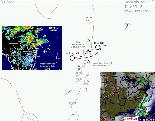
As many researchers have shown, tornadoes like boundaries because they are a source of vorticity ("spin"), among other factors.  The surface map and radar below about 30 minutes before the Ft. Lauderdale downtown tornado suggests that a boundary laid down by an ongoing storm may have helped the second storm trailing along behind it to become tornadic:

As this second storm became dominant and moved along the boundary toward the east-northeast (see radar and satellite below), it produced a weak tornado shortly after 1930 UTC (around 3:35 pm EDT) that was visible as a dust cloud passing through downtown Ft. Lauderdale:

The setting wasn't conducive to strong tornadoes, but in addition to the boundary, the SPC mesoanalysis at 1900 UTC (3:00 pm EDT) showed an environment that was at least marginally supportive of tornadoes.  The first graphic below shows that deep layer wind shear (0-6 km) was around 30 kt, which can support supercells, even though storm-relative helicity (SRH; a source of "spin" for supercell tornadoes) was meager (only around 50 m2/s2):
However, 0-3 km lapse rates were 7.0 to 8.0 deg C/km (see below), a rather steep temperature decrease in the lowest few kilometers that could facilitate low-level stretching.  This is more akin to the High Plains of the U.S. rather than near sea level in Florida, and instability (CAPE) in lowest levels was also plentiful.
The resulting non-supercell tornado parameter showed a maximum near Ft. Lauderdale, and the  energy-helicity index (a supercell tornado forecast parameter) was also marginally above 1.0 in the same area:
While none of these parameters are particularly impressive, the combination of this marginal environment containing moderate to strong instability (>2000 J/kg of total CAPE, not shown) with the boundary noted earlier was apparently enough to generate the Ft. Lauderdale downtown tornado.

The weak tornado at Ft. Lauderdale's major airport around 4:25 PM EDT (2025 UTC) may have also been influenced by another boundary (a broad outflow boundary moving S, see satellite image below).  This boundary could have interacted briefly with yet another storm moving into Ft. Lauderdale from the west:
By any stretch (pun intended), these tornadoes weren't really predictable in advance.  But an alert forecaster might see ingredients coming together in real-time to heighten situational awareness for monitoring of radar and public reports.   

The brief analysis above also suggests that, although the tornadic storms were supercells, some non-supercell/non-mesocyclone processes (related to steep low-level lapse rates along boundaries) may have also been at work for this event.

- Jon Davies  4/11/18