
**** Note -- I added an important update at the bottom of this post on 6/1/16 ****
Most storm chasers count the number of tornadoes they see on any given day. The bigger the number, the more "impressive" a chaser you are, I guess. But many times, from a useful operational meteorological view, such "counts" are inflated.
Last Tuesday (May 24) near Dodge City is a good example. I've heard several storm chasers tell me they saw anywhere from 10 to 17 tornadoes on the prolific tornadic supercell that moved from near Minneola across Dodge City, thankfully missing any direct hits on towns.
My wife Shawna and I followed the storm starting from a distance (near Bucklin, Kansas) up to fairly close just south of Dodge City. I'm conservative regarding tornado counts, and we saw at least 4 "primary" tornadoes, each from its own mesocyclone cycle as new parent circulations developed north or east of each tornado, all fascinating to watch.
Any other tornadoes seemed to be brief and transitional, including a rope tornado in the inflow to the 2nd primary tornado. One of the mesocyclones just SW of Dodge City produced several visual "spin ups" with occasional multiple vortices before putting a fully condensed tornado on the ground. But from a practical viewpoint, I would count that as one intermittent tornado circulation (again, same mesocyclone) instead of several individual tornadoes.
Following is documentation of what we saw using video captures (some of these contrast enhanced to make it easier to see features). All views are toward the west-northwest or northwest.
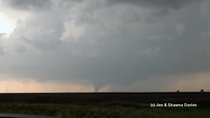
Not counting any brief early touchdowns we couldn't see, here's the first primary tornado touchdown northwest of Minneola, viewed from near Bucklin (25 miles away!) around 6 pm CDT, along with a wide view of the storm (Bill and Anna Stromberg were in the vehicle ahead of us):


Here's the "rope-out" phase of this first tornado, followed by an image that shows where the 2nd primary tornado soon would form:


When the new tornado formed, a thin rope tornado was visible in its inflow stream (see 2nd photo below). Meanwhile, the primary tornado became large but was in poor contrast when viewed from the southeast:


Here's the "rope-out" phase of this 2nd primary tornado, which was on the ground around 15 minutes. Notice a new mesocyclone again to its north or northeast, with a new tornado forming. This new tornado was hard to see (again, poor contrast), did not appear to last that long, and seemed somewhat transitional in nature. So I don't know whether it would be considered a "primary" tornado:


During this phase after the "transitional" tornado dissipated, it was hard to tell if the associated mesocyclone was splitting or just elongating eastward closer to Highway 283. Here's a photo Shawna took:
As we drove closer, the lighting improved, and rapid rotation from this mesocyclone was evident, soon resulting in dust whirls and multiple vortices under a low ragged cloud base.


Fortunately, the elongating tornado moved west of Dodge, while the new mesocyclone dropped a new tornado (the last primary one) north of the town (notice Dodge City and the storm chaser/truck traffic in the foreground):


This last tornado appeared to be on the ground for 5-8 minutes or so, after which we lost sight of it as heavy rain from another storm overtook us from the south around 7:15 pm CDT:

So, based on what we could see with this supercell, there were 4 primary tornadoes on the ground for more than 5-10 minutes each, which seems to agree generally with the map NWS Dodge City put on their web site:

We also saw one peripheral tornado in an inflow band, and one transitional tornado during a mesocyclone evolution phase that was difficult to assess, making 6 total for my conservative count. I don't doubt that there were other brief peripheral or transitional tornadoes that one could count differently, but the 4 primary ones we saw appeared most significant. Sadly, the tornado that passed just west of Dodge City damaged several homes and resulted in 2 injuries.
This event was also notable for the circus of chasers, storm tours, and local traffic jamming up Highway 283 south of Dodge City. One tour van nearly ran over my wife when they abruptly pulled off the highway, even though she was standing well off the road. I'm pretty upset about that, and clearly the traffic issue continues to increase the danger of storm chasing.
If I get time in a few days, I'll post something about the meteorology of this severe event.
Jon Davies - 5/30/16
Update on 6/1/16:
After viewing responses and photos from several other chasers, I clearly need to update my observations/opinions above.
I'll use Dave Lewison's excellent images from Facebook to highlight the changes... here's his Facebook photo link that you should check out. He was farther north on Hwy 283 and in better lighting conditions than Shawna and I were. On a couple of his images re-posted and labeled here, I've inserted/referenced small images from my original post to roughly indicate the corresponding features and phases.
First, when the 2nd primary tornado was on the ground west of Hwy 283, the rope tornado I originally called an "inflow band" tornado was actually a tornado from a new mesocyclone:

Second, shortly after this image, 2 rope tornadoes or vortices were visible under this new mesocyclone northeast of the 2nd primary tornado (I missed these), suggesting that there might have been 3 tornadoes on the ground for a short time:

Third, these appeared to morph into a somewhat larger rope tornado northeast of the 2nd primary tornado that we could not see from farther south in poorer lighting conditions:

And last, when the 2nd primary tornado "roped out", this larger rope tornado became a sizable and probable primary tornado (not a "transitional" tornado as I originally characterized it) while yet another new mesocyclone was forming to its east or northeast:

I don't know how long this new primary tornado lasted because we were fighting traffic and dealing with Shawna's tour bus encounter. But it seems clear from Dave's photos that this was a separate mesocyclone/tornado cycle of its own starting with the earlier rope tornado(s) northeast of the 2nd primary tornado, and not a short "transitional" phase as I characterized it in my original post.
Given this new information, I'd probably update the number of primary tornadoes on the Dodge City NWS map to 5 as follows, changing the "?" to number 3, and moving what I'd shown as numbers "3" and "4" to numbers 4 and 5:

With the new information above, I would probably up my conservative tornado "count" (not that important, and only an opinion!) to 7 tornadoes, and maybe 8 depending on how one might view/interpret things. But certainly, I don't intend that to be definitive, and my original post wasn't meant to ruffle feathers. I only intended to get some discussion going about a fascinating event.
Thanks to Dave Lewison for his images, and for the responses and additional helpful information from several chasers on my wife's Facebook page!
Jon Davies - 6/1/16
21 comments:
I saw 3 on the ground when they first started going strong, I was in a group north of Minneola watching it all start.
Hey, Jon, I'm glad to see you post this. We had a similar conversation during the drive back to Norman (for a midnight shift) - how many tornadoes had we seen? I, too, have been surprised by the 10-17 tornadoes estimates. Like you, I think it's clear there were 4 primary tornadoes, and a few other peripheral/transient circulations. My guess in real time was somewhere in the neighborhood of 6-8, and it's hard for me to argue for more than about 8 after looking back at photos.
Very interesting...great post....
Chasing has unfortunately become like so many other things in life. People are caught up into too much competition in a hurry to get something posted onto social media, so they can have bragging rights as being the best. The desire to try and learn something or even just enjoy the moment is all forgotten............
Awesome image's i just wish there was some videos
Thanks for posting this, Jon. We must have been pretty close at times. I saw 5, though my view of the second primary tornado and the rope to its east was rather poor. It was a really spectacular show of mother nature, however many there were! Sorry to hear about Shawna almost getting hit. I was fortunate not to see much bad behavior by chasers, though I was stuck for a while behind a semi that created a rolling roadblock by driving slowly half on the road and half on the shoulder, even though the nearest vehicle ahead was a quarter mile away. I think the mix of chasers, locals, and over-the-road truckers in the traffic made for a difficult situation.
Thanks for your thoughts, Rich. I really respect your observations and experience. Plus you nailed it with your 10% risk area that morning re tornadoes. Hope your mid shift wasn't too tough after the long drive :-). Take care...
Rebecca:
Appreciate your comment. I've always found the competitive aspect very off-putting... I'm just out there to watch and learn from a safe distance these days. The Dodge City storm was a truly fascinating one to be able to see!
Frisco:
If you have any images of the 3 tornadoes going N of Minneola, I'd love to see them. As I noted, We were quite distant when the first tornado got going. My e-mail is davieswx@gmail.com. Thanks.
Unknown2:
Sounds like we were in similar positions, as the 2nd big tornado was in poor contrast to see from the southeast where we were. Yes, it was a truly spectacular show! And I agree, the traffic mix made it very difficult at times, particularly re Shawna's incident. During the transitional period after the 2nd big tornado roped out, I was driving and it was really hard to watch and interpret what was going on with the storm and new meso(s?) for all the traffic distraction. Take care and stay safe...
Jimmy Deguara here - Same here, I have also kept my comments from posting actual numbers as I understand the definition of what is a tornado. I just said I don't know but it is consistent with the description above. It wax S fascinating event and is why I brave the long, arduous trip to Tornado Aleey to chase. Certainly well worth it! One other thing is I was disappointed to set one well known chaser deliberately running a red light that almost confused me to do likewise! I ended up realising it actually was s red light so stopped!
Hey Jon, Bart Comstock here. The circus on the paved highway was unfortunate and completely avoidable. Multiple times we tried to stay on back roads only to have the sheriff's department block them off and force us all on to the same roads. Had chasers been allowed to spread out the traffic issues would have been much worse. We were able to get on a diet dirt road most of the time but even that one was being used by the LEOs to funnel chasers back to the paved highway. I saw you mentioned a chase tour and wanted to make sure it wasn't one of the vans on my tour. The traffic chaos forced us to split up and I stayed east and mostly in rural areas. If you could send me a private message about who it was I would appreciate it.
It is amazing the amount of stuff you miss once you get more than 2 miles out, though this storm was a weird case where it was quite easy to follow closely and have no rain or hail falling. I stayed just south of the action going up dirt roads 3 miles west of 283 till Saddle Rd when I decided to go east to go around Dodge. The traffic on the dirt roads was not too bad, but the roads got really slick after 20 cars went down them. A couple yahoos, but most maintained safe following distances and passed stopped vehicles carefully.
Your counting method really was not far off IMO, even from being on 283. There were just some interesting things with this storm, especially on the small scale like the satellite circulation that got ingested in the middle of 1st primary tornado's life cycle. I have seen other chaser's videos that make this look like a clearly separate tornado. I think the hardest part is telling the separate circulations apart as they were in very close proximity many times.
I will say I never saw 3 tornadoes at once, but there was a few times there were 3 separate circulations at the cloud level going about their business.
Here is my chase account with pictures and videos from a different angle going from Fowler to 10 miles north of DDC. - http://owlsp.blogspot.com/2016/06/chase-account-may-21-24-2016-ddc-ks.html
Jimmy:
It's great to have Aussies travel all the way to Kansas to see the storms here... And what a supercell this was!
When I was younger, I used to be less careful with my driving, but with the crowded roads and more maturity on my part, I really try to watch out for people and not be a traffic hazard these days :-). Glad you were able to see the red light and stop, unlike the other guy ahead of you. Thanks for your post.
Bart:
It wasn't your tour group, so no worries there.
Shawna and I like approaching the storm from a distance on some dirt roads, but once we hit Hwy 283, that all changed abruptly with the sudden traffic. I didn't realize local LE was funneling cars back to to the paved highway... not sure I understand that strategy.
Thanks for your comments.
Wesley:
Yes, this seemed like a true tornado day with the howling LLJ we woke to in Woodward that morning. Good positioning in Meade on your part. The storm from south of Sitka had an impressive overshooting top when it was organizing.
And, yes, it certainly is easy to miss peripheral/satellite tornadoes when you're watching from several miles away, as some chasers have shown me with their videos. Thanks for mentioning the satellite that we could not see from a distance with the 1st big tornado.
Great photos on your blog! I particularly like seeing the 1st large tornado with the green wheat in the foreground sans powerlines and other chasers :-). And good images of the needle east of big tornado 2!
Thanks for sharing your link and comments.
Jon,
Thanks for posting this. Greg Breneman and I were stalking this beast from a couple miles E of the highway, and had a very good view for a long time. We saw quite a number of rope tornadoes from the long lasting eastern circulation, but we didn't count. Our subjective interpretation was of 10 or more total touchdowns, with a bunch of those being short lived ropes early in the storm on the eastern side.
It gave the impression of having two cyclonic circulations going for quite a while, with them quite close together. Someone else posted that one was anticyclonic which makes more meteorological sense to me, but when I visually looked at them during the chase, they both appeared cyclonic. I pulled archival radar data and the situation was quite messy, but I'm not a pro on interpreting it. Did you observe the long lasting dual mesos also? Any thoughts?
John Moore
Hi Jon...hope you and Shawna are doing well...it's been a LONG time since I've seen you guys...
Interesting blog post...thx for taking the time to do it...
My best!
Joe Lauria
Jon - there was an additional weaker tornado after the last one surveyed N of Dodge City. After the tor warning was dropped the storm briefly ramped up again with several brief touchdowns just W of 283 about 8-9 m SSW of Jetmore. The tornado then planted, wrapped up in rain and moved N basically on 283 for a bit before dissipating. I don't have pics as I was driving at the time but I believe Phil Leonard does. Unsure if it was a new mesocyclone or just the final phases of the one already surveyed.
Hi John:
Good to hear from you... it's been awhile since we've talked.
The dual meso structure you and Greg saw associated with the 2nd large primary tornado and the "needle" tornadoes that eventually evolved to a larger tornado appeared to last at least twenty minutes (from around 6:25 pm to after 6:45 pm) looking back at my video. I didn't see any evidence of anticyclonic circulation under the eastern meso, but we were not observing it close enough to rule that out.
Given that there was a satellite tornado noted by several chasers near the 1st large primary tornado, and the several "needle" tornadoes northeast of the 2nd large primary tornado (the dual meso structure), and Gene above noted a final weak tornado SSW of Jetmore after the tornado north of Dodge, I now think there were probably at least 10 or so tornadoes (generally agreeing with you) that could be legitimately counted, though stil1 5 primary ones associated with the main mesocyclone cycles.
Thanks for your helpful comments.
Hi Joe:
Yes, it's been a long time, no see!
Between major ongoing health problems with Shawna's parents (her father died recently) and other family issues, along with old house "money pit" issues, I've laid low for awhile. Finally getting back to some meteorology work. We'll have to catch up sometime. Hope you're doing well... thanks for your comments.
Jon
Gene:
Thanks for your observation re the last tornado SSW of Jetmore.
I wondered if there were any more tornadoes after we lost sight of the meso north of DDC as rain from the next cell south overtook us. As I mentioned a couple posts up, it sounds like one could legitimately count at least 10 tornadoes now with this event -- 5 primary ones and at least 4-5 others.
Post a Comment