Friday, December 7, 2018

A December (!) cold-core tornado outbreak in Illinois: 12/1/18


Last Saturday's 28 tornadoes in Illinois (IL) were an unusual event so far north in December. I've had several requests to write about it, particularly because it was associated with a cold-core midlevel low (see this 2006 paper, and this one from 2004).  Here's a diagram showing a common "cold-core" type setting that can produce tornadoes:

As is typical in such settings, the storms on 12/1/18 were low-topped and photogenic, as were the tornadoes.  The images at the top of this post by Jed Christoph show the low-topped supercell near sunset that produced an EF3 tornado at Taylorville IL (22 injuries) at dark.  And below are tornadoes near Beardstown and Havana IL, respectively, from an earlier supercell in west-central IL.  In the first image below, notice the surrounding "blue-sky" appearance so common in cold-core type tornado situations. 
The tornadoes came primarily from these two long-track supercells beginning at mid-afternoon (see satellite photo below, and warning summary graphic from NWS Lincoln IL), and lasted into early evening after dark.  Thankfully, there were no deaths due to excellent warnings and generally good visibility.

Here's the 2100 UTC (3 pm CST) surface analysis around the time tornadoes began over west-central IL:


I've been asked why this outbreak wasn't better forecast.  Actually, SPC did have a well-placed 5% probability of tornadoes over west-central and central IL on their Day 1 outlooks during 12/1/18.  But tornado events featuring strong tornadoes associated with midlevel cold-core lows are, quite frankly, notoriously hard to pick out (see also 7/19/18 in Iowa).

A significant issue is usually instability (CAPE) that appears less robust with a narrower axis than most strong tornado settings we're used to seeing in the Plains.  Because of colder air aloft associated with midlevel lows, what appears to be relatively weak total CAPE can be misleading, with the relevant CAPE usually located closer to the ground in cold-core scenarios. This can set the stage for increased tilting and stretching of vorticity as air in storm updrafts accelerates upward.

Forecast models on December 1 actually did a good job of placing synoptic features and convective precipitation (below).  The 0-1 km energy-helicity index (EHI) combining CAPE and low-level shear often doesn't work well in cold-core tornado settings due to the smaller total CAPE values.  However, in this case, the morning RAP forecast graphics for mid-afternoon on 12/1/18 did suggest that sizable 0-1 km EHI values would be co-located with storms over west-central and central Illinois:


The midlevel low in this case was located farther west than in most cold-core tornado events, 350 to 400 miles west of the surface warm sector and boundary intersection, instead of within 200-250 miles.  But because the low was embedded within a large upper long wave trough in December (see the NAM 700 mb forecast below, first panel), cold air aloft in midlevels had spread far to the east over most of Illinois (note the blue-dotted freezing line in the same NAM forecast panel):


With 50's F surface dew points in the surface warm sector over Illinois beneath the cold air aloft (see surface map earlier), total CAPE values of 1000-1200 J/kg were forecast over Illinois (see second panel above).  This is is pretty decent instability for a cold-core type event, certainly larger than the 200-500 J/kg found in many cold-core settings.

As mentioned earlier, low-level CAPE (in roughly the lowest 3 km above ground) appears to be a significant factor in stronger cold-core events, enhancing low-level stretching.  Typical 0-3 km MLCAPE associated with tornado events is on the order of 50-75 J/kg.  But on 12/1/18, an axis of 0-3 km MLCAPE values near 200 J/kg (see below) was evident over western and central IL on the SPC mesoanalysis at mid and late afternoon, co-located with ongoing convective storms.  Sizable low-level shear (0-1 km storm-relative helicity/SRH of 200-400 m2/s2) was also present:


Such large low-level CAPE isn't directly evident when examining just total CAPE values, and when combined with sizable low-level shear, it can result in strong tilting and stretching of horizontal vorticity in storm updrafts.

I've been experimenting with a version of EHI (0-1 km "enhanced" EHI) that incorporates low-level CAPE to boost the parameter values in situations where large 0-3 km CAPE is present.  Below are both the effective signifcant tornado parameter (STP) fields and enhanced EHI fields for 2100 UTC and 2300 UTC (mid to late afternoon) from the SPC mesoanalysis on 12/1/18.  Note how the enhanced EHI values (EEHI) were larger due to the incorporation of the low-level CAPE in this "cold-core" scenario:


The RAP model 1-hour forecast sounding at Taylorville IL (TAZ) shortly before the EF-3 tornado confirmed the presence of large low-level CAPE (near 200 J/kg), along with large low-level shear (0-1 km SRH around 375 m2/s/):


It's interesting to note that the low-level hodograph on this profile through 3 km above ground looks like an almost "perfect" half circle.  That's very optimal shear available for tilting and stretching into an updraft boosted by large low-level CAPE and upward acceleration in the lowest 3 km.  Having > 60 kts of deep-layer (0-6 km) shear in the environment also helped to organize and strengthen the Taylorville storm's updraft.

Here's an image of the wedge-like Taylorville tornado when it was well southwest of the town before dark:


And here's the tornado moving through Taylorville, at dark, illuminated by power flashes:


Some final thoughts to wrap up here... First, in addition to the seasonal lateness, number/intensity of tornadoes, and westward distance of the midlevel low,  this cold-core event was also somewhat unusual in that the bulk of the tornadoes (particularly the Taylorville storm) occurred well within the warm sector south of the warm front, instead of close to the boundary intersection of the Pacific cool front/dryline and warm front.  That seems to be because low-level shear was strong deep into the warm sector and co-located with large warm sector low-level CAPE.  Cold-core setups in the warm season often lack low-level wind shear except near the warm front and boundary intersection, but that certainly wasn't the case here with this cool season event.

And lastly, this event, along with the 7/19/18 cold core tornado event in Iowa this year, makes me wonder if model forecast graphics of 0-3 km CAPE (not found on commonly-used model forecast web sites apart from the SPC mesoanalysis) should be more available for web users.  An incorporation of low-level CAPE into composite tornado parameters might also help in picking out these stronger cold-core type tornado outbreaks.  

In any event (pun intended), this was certainly a fascinating case for the first day of December.

- Jon Davies  12/7/18  

Thursday, September 20, 2018

Florence spawns a killer tornado near Richmond, Virginia on 9/17/18


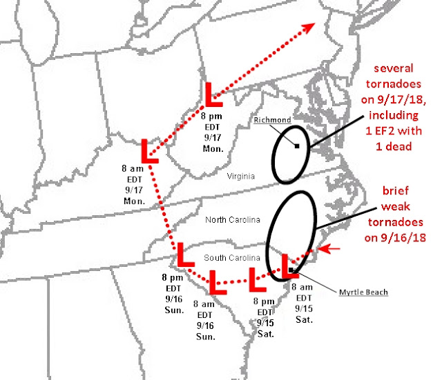
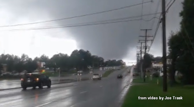
Anyone following the news the past week knows that Florence was a devastating hurricane in North Carolina (NC), South Carolina (SC), and Virginia (VA), with at least 37 deaths so far.  The Carolinas deaths were mainly flood-related due to Florence's slow movement and deluge of rain, and with such a large and wet tropical system, tornadoes were probably the least of most people's worries.  But tornadoes did occur, particularly on Monday the 17th when one person died in a tornado that hit the Richmond, Virginia area (see above).

There were around 100 tornado warnings issued during Florence and her remnant's slow journey inland from Thursday 9/13/18 through Monday 9/17/18.  Yet the 17th turned out to be the only truly significant tornado day of Florence's 5-day assault on the mid-Atlantic states.  After my last post about tornadoes from the remnants of Gordon on September 8, I thought it would be interesting to look at possible reasons why the strongest and longest track tornadoes were on the 17th, several days after Florence's landfall.

The inland track of the center of Florence and her remnants from Friday 9/15/18 through Monday evening 9/17/15 is shown below, with times marked:
A few reports of brief weak tornadoes began coming in on the evening of the 15th near Wilmington NC, but the most tornadoes associated with Florence occurred on the 16th (brief and weak), and on the 17th (stronger and longer-lived), as indicated on the graphic above.  But again, why was Monday the 17th the most prolific tornado day?

First, from classic research on hurricane tornadoes, such as McCaul's August 1991 paper, the strongest and most numerous tornadoes with tropical systems are most likely in their right front quadrant (looking downwind along the direction of movement).  More recent studies, such as Verbout et al. (2006) also suggest that tropical systems recurving to the northeast inland over the eastern U.S. are more likely to produce tornadoes.

Such recurvature is usually due to tropical systems meeting and merging with westerly or southwesterly flow from a mid or upper level trough as the remnants move northward (this can increase the surrounding deep-layer wind shear to better support supercells and possible tornadoes -- more on than later).  It is interesting that Florence's remnants did indeed merge with such a trough, as seen on the 500mb charts below (roughly 18,000 ft above sea level) for both 9/16/18 and 9/17/18:


From our tracking chart earlier, notice that Florence's center by daytime on the 17th was moving faster and actually curving back to the northeast, a result of it merging with the westerly flow aloft and the 500mb trough.  Even though Florence's remnants were more spread out at this point, this change in movement and direction still put Virginia in the right front quadrant of the remaining tropical system center on Monday the 17th, a favored location for tornadoes from the research noted earlier.  It is notable that the Virginia tornadoes occurred during the period of Florence's remnants recurving northeastward on the 17th.

Second, looking at tornado forecasting parameters from the Storm Prediction Center (SPC) mesoanalysis, the environment associated with Florence's remnants over land appeared most favorable over Virginia on the afternoon of the 17th, particularly when compared to the 16th.  This can be seen from the Enhanced Energy-Helicity Index (EEHI) parameter, which combines low-level wind shear and instability (important supportive factors for supercell tornadoes), shown below:
Note that EEHI values most supportive of supercell tornadoes remained largely over water on the 16th.  But, on the afternoon of the 17th, large EEHI values came together inland over Virginia where thunderstorms were occurring with the spread out remnants of Florence as the remaining circulation center over West Virginia now moved northeastward.

Although low-level shear near ground (typically in the 0-1 km layer) is a key factor in hurricane tornadoes, deeper-layer shear (throughout the 0-6 km layer) also appears to be a factor for tornado development and strength with tropical systems over land (see my 2006 paper here).  Stronger deep-layer 0-6 km shear (larger than 30 kt or 15 m/s) seems to be important in such cases.  Comparing analyses of this deeper-layer shear (below) on the 16th with the 17th, notice how the 0-6 km deep-layer shear was rather weak (< 30 kt) over the Carolinas on the 16th, but was stronger (> 30 kt)  over Virginia on the 17th where the killer tornado occurred near Richmond. This was a result of Florence merging with the 500mb trough and westerly flow aloft, discussed earlier:
Stronger deep-layer shear helps strengthen and organize convective updrafts, and can help to support tornadoes when combinations of low-level shear and instability are also in place.

It is interesting that on the 16th, with weaker deep-layer 0-6 km wind shear, a supercell tornado over water (a 'tornadic' waterspout) came directly ashore in Myrtle Beach SC (see image below), but produced little reported damage over land (probably EF0 in intensity):


This is in contrast to the killer EF2 tornado near Richmond VA on the 17th (below) when low-level shear and instability combinations appeared more favorable (see the EEHI graphic earlier), and were  supported by an area of stronger deep-layer 0-6 km shear over Virginia (see the 0-6 km shear graphic earlier); this stronger deep-layer shear was absent over the Carolinas the day before.  Here's some more images of the large Richmond tornado:


Distinguishing tropical systems that produce stronger or more numerous tornadoes from those that don't produce tornadoes or are associated with brief weak tornadoes is difficult and certainly not that well understood.   But some of the factors discussed above can be helpful at times in forecasting such tornadoes.

If you can, please donate to a charitable organization to help with recovery from Hurricane Florence.

-  Jon Davies  9/20/18

Monday, September 10, 2018

September 8, 2018 Kentucky-Indiana tornadoes from remnants of tropical storm Gordon


It's the middle of hurricane season, with dangerous hurricane Florence bearing down on the Carolinas later this week.  Hurricanes and tropical systems can produce tornadoes, particularly in their right front quadrant.  So, I thought it would be interesting to look back at last week's much weaker tropical system (Gordon) that produced some tornadoes (see above) in Kentucky and Indiana on Saturday, September 8.

Gordon never quite made it to hurricane strength before landfall on September 4 in the Mississippi/Alabama/northwest Florida coastal area, and only produced one or two very brief weak tornadoes on the 4th and 5th with little or no damage.  But then, after a couple of days with no tornadoes, the remnants of Gordon produced several tornadoes on September 8 far inland in northern Kentucky (KY) and southern Indiana (see area indicated on the 2 pm CDT surface map below):

This included one tornado of EF1 intensity at Stanley KY, just west of Owensboro, shown at the top of this post.  Why would Gordon suddenly start producing tornadoes again four days after landfall?

By Saturday the 8th, after having moved northwestward in weak upper flow for three days, Gordon's remnants had merged with a non-tropical midlevel disturbance evident at roughly 20,000 ft MSL (dashed heavy red line on the 3 pm CDT SPC mesoanalysis 500 mb map below):

This caused Gordon's remnants to "recurve" to the east-northeast as a surface low along an east-west quasi-stationary front over the Ohio Valley (see the surface map earlier).  The 3-panel map below shows this recurvature of Gordon's path (red squares and dashed lines) during September 4th through the 8th:


This graphic also shows deep-layer wind shear (surface to 6 km above ground, in blue lines) on September 4th, 6th, and 8th.  Notice how the shear weakened and essentially disappeared as Gordon's remnants moved farther inland on the 6th and 7th.  But by Saturday the 8th, when encountering energy from the midlevel disturbance, the wind shear dramatically increased near Gordon's remnants over the Ohio Valley.  This is what helped to produce the tornadoes, because supercell tornadoes, along with an unstable environment, typically require sizable wind shear (a change in wind direction and increase in wind speed with height) to develop.

At 3 pm CDT on the 8th, instability and wind shear together (shown using an enhanced version of the energy-helicity index or EHI) highlighted an area supportive of tornado development on SPC graphics along the Ohio River border area of Indiana and Kentucky , which is where the tornadoes occurred:

Thankfully, the tornadoes weren't that strong, but the one at Stanley KY did do notable damage to several homes, and was widely photographed:

Hurricane Florence (category 4 as I write this) poses a much bigger threat than Gordon's localized tornadoes when it hits the Carolinas on September 13 and 14.   Wind driven storm surge, heavy rain, and flooding will likely be huge and potentially life-threatening issues, and I'm just hoping it won't be as bad as most forecasters are thinking.

-  Jon Davies  9/10/18

Sunday, July 22, 2018

A "surprise" tornado outbreak in Iowa on July 19, 2018


Thursday's biggest weather news wasn't tornadoes.  The tour boat sinking from strong thunderstorm winds at Table Rock Lake near Branson in southwest Missouri was a deeply sad tragedy that killed 17 people.  Much has been written online about this event, which was likely preventable if the tour company had called in all boats on the lake immediately after a severe thunderstorm warning was issued at 6:23 PM CDT, roughly 30 minutes before the sinking.  The issues involved are similar to those raised by a deadly outdoor concert stage collape in Indiana back in August 2011 (see my archived article here).

However, this post is a look at the meteorological setting that produced tornadoes in Iowa on 7/19/18..

Thursday's tornadoes in central Iowa were another 2018 "surprise" of sorts. Morning forecast outlooks (not shown) had a 2% or less chance of tornadoes over central and eastern Iowa, and a tornado watch wasn't issued until after the first tornadoes were on the ground doing damage.  But, after the watch was in effect, tornado warnings continued to be issued, including for the strongest tornadoes (EF3) at Marshalltown and Pella (see images above) around and after 2100 UTC (4 pm CDT).  Thankfully, there were no fatalities.

Believe it or not, this event had some aspects of a "cold-core" tornado event (see my 2006 paper here).  Even though there was not a closed low at 500 mb (roughly 18,000 ft MSL, not shown), a closed low was evident at 700 mb (around 10,000 ft MSL) moving east-southeast over Minnesota and Iowa (see middle panel below).  In fact, this same system produced tornadoes on three days in a row (July 18 through 20):
This compact 700 mb system had good dynamic lifting for generating severe storms ahead of it, and  Thursday's setting seemed to optimize the setting, with cool air aloft sliding southeast above very warm and moist air at the surface, resulting in strong instability for a cold-core system.  A surface warm front over central Iowa was also a key feature (see middle graphic below) for generating low-level wind shear, as is true with many cold-core systems:


Notice that on all three days (July 18 through 20), tornadoes occurred near the surface warm front southeast of the closed low aloft, with Thursday 7/19/18 the biggest day (a local "outbreak").

Looking more specifically at environmental ingredients on 7/19/18, the mid-morning HRRR model run forecast large storm-relative helicity (SRH, or low-level wind shear) for the afternoon over central Iowa along and northeast of the surface warm front where winds were backed and coming from a more easterly direction.  This was co-located with a gradient of increasing instability (CAPE, or convective available potential energy) along the warm front, making for good combinations of instability (CAPE) and low-level wind shear (SRH) to promote storm rotation along and just northeast of the surface warm front (see red ellipses on the HRRR forecast graphics below, valid at 1900 UTC (2 pm CDT).


By 2200 UTC (5 pm CDT) the HRRR model forecast of radar reflectivity suggested two supercells east of Des Moines, with associated updraft helicity tracks (a model forecast of storm rotation) evident with those cells in the 2200 - 2300 UTC time frame:
As it turned out, thunderstorms began to form over central Iowa shortly after 1900 UTC, two to three hours earlier than forecast by the HRRR model.  A cell east of Des Moines rapidly became a supercell, and produced several tornadoes, including a couple at the same time.  An EF2 tornado near Bondurant occurred already by 2000 UTC (3 pm CDT, not shown).

At 2100 UTC (4 pm CDT), real-time SPC mesoanalysis graphics (below) confirmed the large SRH and low-level wind shear over the eastern half of Iowa.  Instability in low-levels closest to the ground (below 3 km) was also unusually large in central Iowa (see the upper right panel of the graphic below) near the warm front.  This was due to the colder air ("cold-core") aloft around 700 mb moving southeast above surface air with dew points in the 70s deg F, which is extremely moist for a cold-core type event.


The lower left panel above shows an enhanced version of the energy-helicity index (EHI) that I've developed, combining CAPE, SRH, deep-layer shear, and low-level CAPE, ingredients important for supporting supercell tornadoes.  This was at 2100 UTC, about the time of the Pella tornado (southernmost supercell in Iowa), and shortly before the Marshalltown tornado (next supercell to the north).  Notice how this parameter was maximized directly in the area where the two tornadic supercells were moving east or east-southeastward.  The SPC significant tornado parameter at 2100 UTC (lower right panel above) showed a similar pattern.

So, analyses and model forecasts from mid-morning on, if studied carefully, did seem to suggest an environment conducive to possible supercells and tornadoes over the eastern half of Iowa, even though they were too slow on the initiation of storms.  These ingredients, combined with the presence of an advancing closed 700 mb low disturbance from the northwest, and a surface warm front, appeared to optimize the setting for tornadoes over the eastern half of Iowa.

Cold-core type settings can produce tornadoes rapidly when the ingredients come together right, and that was the case here.  The tornadoes near Bondurant, IA (east-northeast of Des Moines) around 2000 UTC (3 pm CDT) developed only 30 to 45 minutes after this cell was visible on radar.  Part of this rapid development may have been due to the large low-level CAPE near the ground (refer back to the upper right hand panel of the 4-panel SPC mesoanalysis graphic earlier).  The large 0-1 km SRH co-located with this strong low-level instability may have facilitated low-level storm updraft stretching and vertical tilting of horizontal wind shear (SRH) to help generate tornadoes within a relatively short time.

My wife Shawna mentioned the presence of what appeared to be a closed low aloft from satellite and radar loops on TV on the morning of 7/19/18.  But we were packing and shutting down her mother's apartment that day (Shawna's mom recently moved to a nursing home), so I didn't give it much thought.  It's important to remember that closed lows with their cold air aloft and tight, strong dynamics can sometimes result in "surprises" if one isn't paying attention.

In addition to the tornadoes, the Table Rock Lake tragedy on 7/19/18 was a stunning reminder that thunderstorm winds can be as deadly as tornadoes.  What a sad day.

- Jon Davies  7/22/18

Wednesday, June 27, 2018

The Eureka KS tornado, June 26 2018: A "surprise" of sorts.


The tornado that struck Eureka, Kansas on Tuesday evening (see video image above) occurred without a watch, and though the storm was tornado-warned, it was with little or no lead time.  Unfortunately, 8 people were injured, and this event was something of a "surprise."

Severe weather forecasting often gets more difficult as summer moves in because weather systems and their ingredients are more subtle, and the atmosphere is already unstable across much of the U.S.  In that context, this post is a brief analysis suggesting some ingredients that appeared to contribute to the tornado.

Storms that formed over eastern Kansas and Missouri around midday on June 26, 2018 moved southeast as a large complex of thunderstorms, leaving an outflow boundary trailing back into southeast Kansas by late afternoon (see black circled area on the surface map below, around 6:00 pm CDT):

This boundary could also be seen from careful examination of visible satellite between 6:40 and 7:05 pm CDT (see white arrows below):
On the images above, a severe storm in progress was just northeast of Wichita, Kansas, but the developing Eureka storm could be seen (barely) on the last image at the east edge of the anvil of the ongoing storm farther west (see black arrow on 2nd image above).  Notice that the Eureka storm's location appeared to be essentially right on the aforementioned outflow boundary, compared to the storm closer to Wichita.

To see how rapidly the Eureka storm developed, look at these high-resolution satellite images zoomed in on southeastern Kansas at 4 minute intervals between 6:50 pm and 6:58 pm CDT:


As it punched through the eastern edge of the ongoing anvil to its west, the rapid growth of the Eureka storm's overshooting top (see black arrows above) was quite impressive, in an environment.where instability was large (MLCAPE > 3000 J/kg, not shown).  Radar images from Wichita also show this rapid development, with notable rotation developing in the storm barely 30 minutes into its life cycle:


The tornado formed about 7:18 pm CDT, and was photographed from the nearby countryside by local resident Gary Williams as it moved east (see image at the top of this post, as well as the two below). The mesocyclone became wrapped in rain (see 2nd image below), which may have hidden the tornado, and could explain why more photos of the tornado haven't materialized.


Why did this significant and destructive tornado develop with this particular storm, and not with the picturesque and striated evening supercells back to the west?  (See the image below by Ken Engquist near Wichita a little later in the evening.)

Going back to the earlier surface map and 2-panel low-res satellite image near the beginning of this post, it appears that the Eureka storm developed right on the trailing outflow boundary from the storms earlier in the day.  A common theme with my occasional blog posts this year has been that tornadoes tend to be associated with boundaries in unstable settings where wind shear, along with other ingredients supportive of tornadoes, tend to be maximized.

Below are panels from the SPC mesoanalysis showing low-level wind shear (storm-relative helicity or SRH), as well as low-level CAPE/instability, and the energy-helicity index (EHI), a parameter that highlights areas where both instability and SRH may be supportive of tornadoes should storms develop within that environment:  


Notice that the low-level wind shear (SRH) was maximized along the outflow boundary over southeast Kansas, and that there was some CAPE below 3 km on the west side of the outflow boundary near the developing tornadic storm.  This suggests an unstable surface-based environment near the Eureka storm, also important (in addition to wind shear) for supporting significant tornadoes.  The resulting energy-helicity index in the 3rd panel above was also maximized near and west of the boundary near the Eureka storm, suggesting support for supercell tornadoes.

It is impossible to say exactly why the Eureka storm was tornadic, and why the others were not (a very brief rope tornado did occur northwest of El Dorado, Kansas around 5:30 pm CDT).  But the presence of the trailing outflow boundary matches well with the location of the Eureka storm, and that certainly could have had some influence on that storm producing a significant tornado.

The larger scale setting (from the 12-hour NAM model 500 mb forecast valid at 7:00 pm CDT, showing features at roughly 18,000 ft MSL) indicates that there was a shortwave disturbance (heavy dashed red line) moving southeast across eastern Kansas:  


This was on the back side of a closed upper low over Wisconsin (this same low helped to produce other tornadoes in southern Wisconsin and northern Illinois on June 26).  The shortwave disturbance helped provide lift for generating the evening thunderstorms in the unstable air over the southeast quarter of Kansas, and the stronger winds aloft associated with this disturbance (around 40 kts) also helped to support supercell storms in this setting.

So, while the tornado potential over southeast Kansas was not easy to forecast on June 26, 2018, a careful analysis of ingredients and features in the 1-2 hours before the Eureka event shows several factors coming together that might support a significant tornado or two. This was particularly true along the outflow boundary where the Eureka storm developed explosively.

An interesting fact:  Eureka was hit by another EF3 tornado just 2 years ago, in July 2016 !

- Jon Davies  6/27/18

Sunday, June 17, 2018

Our intense downburst experience on I-29 in southwest Iowa - June 11, 2018


Last week, on Monday, June 11, my wife Shawna and I were able to get away from family health and caregiving issues in Kansas City for an afternoon in eastern Nebraska, our first chase since May 1.  We saw what appeared to be a brief tornado northwest of Omaha, but more importantly, we witnessed a damaging downburst (see diagram and image above) crossing into southwest Iowa north of Nebraska City.  It's been an extremely busy week, so I'm just now getting around to doing a post about this interesting event.

We were heading south on I-29 around 7:00 pm CDT (0000 UTC) to get back to Kansas City, thinking we could outrun a supercell and developing squall line on the west side of the Missouri River.  As we drove south, we were surprised to see the storms rapidly and unexpectedly bow swiftly eastward, crossing I-29 in our path with winds in the 80-90 mph range (an 88 mph gust was recorded near Thurman, Iowa).  This wet bowing downburst felt very much like being in the eyewall of a hurricane, and several semi tractor-trailers were overturned on I-29.   Damage to trees, roofs, and buildings was also reported from near Union, Nebraska, to Thurman and Sydney, Iowa.

Here's an image from Shawna's video of the developing squall line as it overtook the supercell to our west shortly before 7 pm CDT (0000 UTC):


And here are video capture images of the downburst racing across I-29 in front of us, looking south: 

These images were at roughly 10 second intervals during a 30 second period just after 7 pm CDT (0000 UTC), and the arrows mark the leading edge of the precipitation-laden downburst, showing just how fast it was moving and accelerating! 

These next two images shows how conditions became almost "white-out" as the rain and wind engulfed us:


The downburst overturned 9 semi tractor-trailors on I-29 just ahead of us (3 miles west of Thurman), and one semi tractor-trailer rig on its side blocked the road in front of us:


In pouring rain and strong winds, Shawna jumped out to see if the driver was all right.  Anyone who is acquainted with my wife knows that she has a passion for helping out and knowing what to do after destructive weather and before first responders arrive. 

A level-headed Quik Trip truck driver also stopped beside us, and helped pull the semi driver out of his cab.  Shawna brought him over to our vehicle, where we could see a sizable gash on his arm and some cuts to his face from falling when his semi flipped over in the 80+ mph downburst winds.  

We dug out towels to wrap his arm, called 911, and waited for help.  After a bit, a state trooper began directing traffic along the narrow side shoulder to squeeze past the blocking semi, and told us to go to the next exit to wait for an ambulance.  To save time, we decided to drive on down to Nebraska City, where Shawna took the injured driver into a hospital emergency room.  Thankfully, his injuries weren't life-threatening, and we resumed our journey home, wishing him the best after he called his wife.

Going back to look briefly at data from a meteorological standpoint, the downburst appeared to develop when a line of storms was building after 6:00 pm CDT (2300 UTC) along the surface cool front back to the west near Lincoln (see radar images below, base reflectivity at left, base velocity at right for 6:13 pm):  
This was an area where there was both drier air aloft near the front, and a relatively dry layer below cloud base due to wide temperature-dew point spreads (see model sounding near Lincoln at 6:00 pm CDT / 2300 UTC below):  

Evaporation from rain falling through such dry layers can cool already precipitation-laden air even more to generate strong negative buoyancy and accelerate winds downward and forward to create a downburst.

This line began to show an area of stronger low-level winds (go back to the radar images above at 6:52 pm CDT / 2352 UTC and 7:05 pm CDT / 0005 UTC), overtaking the supercell that had earlier produced some brief weak tornadoes south of Omaha, near Louisville, Nebraska.  This area then bowed very fast across the Missouri River to intercept our path as the corridor of strong downburst winds accelerated eastward.

An additional note:  Earlier in the afternoon, we did see something that looked like a brief tornado near Fremont, Nebraska,  but we did not hear of any damage from this feature:

This possible tornado was from a tornado-warned supercell near the intersection of the cool front and a residual outflow boundary from convection earlier in the day. 

So, Monday, June 11 made for an unexpectedly interesting storm chase.  It sounds like there were no critical injuries (including the driver we took to the hospital), so we are very grateful!

- Jon Davies  6-17-18